Back مقاطعة ماريز (ميزوري) Arabic Maries County, Missouri BAR Мерис (окръг, Мисури) Bulgarian মারিয়েস কাউন্টি, মিসৌরি BPY Maries Gông (Missouri) CDO Мэрис (гуо, Миссури) CE Maries County CEB Maries County, Missouri Welsh Maries County German Condado de Maries Spanish
Maries County | |
|---|---|
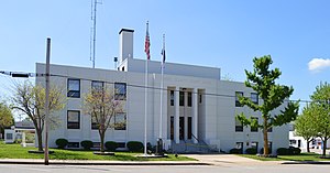
 Maries County Courthouse | |
 Location within the U.S. state of Missouri | |
 Missouri's location within the U.S. | |
| Coordinates: 38°11′N 91°55′W / 38.18°N 91.92°W | |
| Country | |
| State | |
| Founded | March 2, 1855 |
| Named for | The Maries River and Little Maries River |
| Seat | Vienna |
| Largest city | Belle |
| Area | |
| • Total | 530 sq mi (1,400 km2) |
| • Land | 527 sq mi (1,360 km2) |
| • Water | 2.9 sq mi (8 km2) 0.6% |
| Population (2020) | |
| • Total | 8,432 |
| • Density | 16/sq mi (6.1/km2) |
| Time zone | UTC−6 (Central) |
| • Summer (DST) | UTC−5 (CDT) |
| Congressional district | 3rd |
| Website | www |
Maries County is a county located in the U.S. state of Missouri. As of the 2020 census, its population was 8,432.[1] Its county seat is Vienna.[2] The county was organized March 2, 1855, and named for the Maries River and Little Maries River. The word "Maries" is derived from the French word marais, which means "marsh, lake, or pond".
- ^ "Explore Census Data". data.census.gov. Retrieved December 23, 2021.
- ^ "Find a County". National Association of Counties. Retrieved June 7, 2011.
© MMXXIII Rich X Search. We shall prevail. All rights reserved. Rich X Search