Martinborough
Wharekaka (Māori) | |
|---|---|
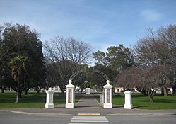
 Martinborough's Memorial Square | |
 | |
| Coordinates: 41°13′8″S 175°27′33″E / 41.21889°S 175.45917°E | |
| Region | Wellington Region |
| Territorial authority | South Wairarapa District |
| Ward | Martinborough Ward |
| Community | Martinborough Community[1] |
| Electorates | |
| Government | |
| • Territorial Authority | South Wairarapa District Council |
| • Regional council | Greater Wellington Regional Council |
| • Mayor of South Wairarapa | Martin Connelly |
| • Wairarapa MP | Mike Butterick |
| • Ikaroa-Rāwhiti MP | Cushla Tangaere-Manuel |
| Area | |
| • Total | 4.86 km2 (1.88 sq mi) |
| Population (June 2023)[3] | |
| • Total | 2,060 |
| • Density | 420/km2 (1,100/sq mi) |
| Time zone | UTC+12 (NZST) |
| • Summer (DST) | UTC+13 (NZDT) |
| Postcode(s) | 5711 |
| Area code | 06 |

Martinborough (Māori: Wharekaka or Māori: Huangarua)[4] is a town in the South Wairarapa District, in the Wellington region of New Zealand. It is 65 kilometres east of Wellington and 35 kilometres south-west of Masterton. The town has a resident population of 2,060 (June 2023).[3]
The town is home to the South Wairarapa District Council.
- ^ "Martinborough Community Board". South Wairarapa District Council. Retrieved 4 February 2022.
- ^ Cite error: The named reference
Areawas invoked but never defined (see the help page). - ^ a b "Subnational population estimates (RC, SA2), by age and sex, at 30 June 1996-2023 (2023 boundaries)". Statistics New Zealand. Retrieved 25 October 2023. (regional councils); "Subnational population estimates (TA, SA2), by age and sex, at 30 June 1996-2023 (2023 boundaries)". Statistics New Zealand. Retrieved 25 October 2023. (territorial authorities); "Subnational population estimates (urban rural), by age and sex, at 30 June 1996-2023 (2023 boundaries)". Statistics New Zealand. Retrieved 25 October 2023. (urban areas)
- ^ "Huangarua - te Aka Māori Dictionary".
© MMXXIII Rich X Search. We shall prevail. All rights reserved. Rich X Search
