Back مقاطعة ماتاغوردا (تكساس) Arabic ماتاقوردا بؤلگهسی، تکزاس AZB Matagorda County, Texas BAR Матагорда (акруга) Byelorussian Матагорда (окръг, Тексас) Bulgarian মাতাগোর্ডা কাউন্টি, টেক্সাস BPY Matagorda Gông (Texas) CDO Matagorda County CEB Matagorda County Czech Matagorda County, Texas Welsh
Matagorda County | |
|---|---|
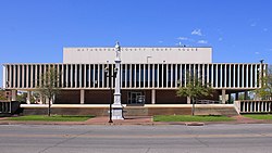
 The Matagorda County Courthouse and Confederate Soldier Statue in Bay City | |
 Location within the U.S. state of Texas | |
 Texas's location within the U.S. | |
| Coordinates: 28°47′N 96°00′W / 28.78°N 96°W | |
| Country | |
| State | |
| Founded | 1836 |
| Seat | Bay City |
| Largest city | Bay City |
| Area | |
| • Total | 1,613 sq mi (4,180 km2) |
| • Land | 1,100 sq mi (3,000 km2) |
| • Water | 512 sq mi (1,330 km2) 32% |
| Population (2020) | |
| • Total | 36,255 |
| • Density | 22/sq mi (8.7/km2) |
| Time zone | UTC−6 (Central) |
| • Summer (DST) | UTC−5 (CDT) |
| Congressional district | 22nd |
| Website | www |

Matagorda County is a county located in the U.S. state of Texas. As of the 2020 census, the population was 36,255.[1] Its county seat is Bay City,[2] not to be confused with the larger Baytown in Harris and Chambers Counties. Matagorda County is named for the canebrakes that once grew along the coast (matagorda is a Spanish word meaning "thick bush").
Matagorda County comprises the Bay City, TX Micropolitan Statistical Area, which is also included in the Houston-The Woodlands, TX combined statistical area.
- ^ "Matagorda County, Texas". United States Census Bureau. Retrieved February 23, 2021.
- ^ "Find a County". National Association of Counties. Retrieved June 7, 2011.
© MMXXIII Rich X Search. We shall prevail. All rights reserved. Rich X Search