Back إقليم مولي Arabic Мауле (өлкә) Bashkir Región del Maule BAR Мауле (регион) Bulgarian Rannvro Maule Breton Regió del Maule Catalan Maule (rehiyon) CEB Maule Czech Maule (region) Danish Región del Maule German
Maule Region
Región del Maule | |
|---|---|
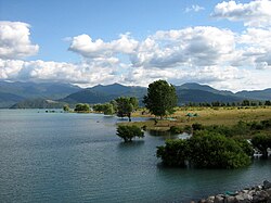
 Colbún Lake | |
 Map of Maule Region | |
| Coordinates: 35°26′S 71°40′W / 35.433°S 71.667°W | |
| Country | |
| Capital | Talca |
| Provinces | Curicó, Talca, Linares, Cauquenes |
| Government | |
| • Intendant | Pablo Milad (Evopoli) |
| Area | |
| • Total | 30,296.1 km2 (11,697.4 sq mi) |
| • Rank | 9 |
| Lowest elevation | 0 m (0 ft) |
| Population (2017 census)[1] | |
| • Total | 1,033,197 |
| • Rank | 4 |
| • Density | 34/km2 (88/sq mi) |
| GDP (PPP) | |
| • Total | $10.998 billion (2014) |
| • Per capita | $10,620 (2014) |
| ISO 3166 code | CL-ML |
| HDI (2019) | 0.790[3] high |
| Website | Official website (in Spanish) |
The Maule Region (Spanish: Región del Maule, pronounced [ˈmawle]) is one of Chile's 16 first order administrative divisions. Its capital is Talca. The region derives its name from the Maule River which, running westward from the Andes, bisects the region and spans a basin of about 20,600 km2. The Maule river is of considerable historic interest because, among other reasons, it marked the southern limits of the Inca Empire.
- ^ a b "Maule Region". Government of Chile Foreign Investment Committee. Retrieved 13 March 2010.[permanent dead link]
- ^ Regions and Cities > Regional Statistics > Regional Economy > Regional GDP per Capita, OECD.Stats.
- ^ "Sub-national HDI - Area Database - Global Data Lab". hdi.globaldatalab.org. Retrieved 26 October 2021.
© MMXXIII Rich X Search. We shall prevail. All rights reserved. Rich X Search

