Back مقاطعة مايز (أوكلاهوما) Arabic Mayes County, Oklahoma BAR Мейс (окръг, Оклахома) Bulgarian মায়েস কাউন্টি, ওকলাহোমা BPY Mayes Gông (Oklahoma) CDO Mayes County CEB Mayes County, Oklahoma Welsh Mayes County German Condado de Mayes Spanish Mayes konderria (Oklahoma) Basque
Mayes County | |
|---|---|
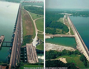
 Pensacola Dam on the Neosho River in-between Disney and Langley on Oklahoma State Highway 28, creating Grand Lake o' the Cherokees. | |
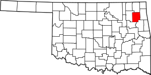
 Location within the U.S. state of Oklahoma | |
 Oklahoma's location within the U.S. | |
| Coordinates: 36°18′N 95°14′W / 36.3°N 95.24°W | |
| Country | |
| State | |
| Founded | November 16, 1907 |
| Named for | Samuel Houston Mayes |
| Seat | Pryor Creek |
| Largest city | Pryor Creek |
| Area | |
| • Total | 684 sq mi (1,770 km2) |
| • Land | 655 sq mi (1,700 km2) |
| • Water | 28 sq mi (70 km2) 4.1% |
| Population (2020) | |
| • Total | 39,046 |
| • Density | 57/sq mi (22/km2) |
| Time zone | UTC−6 (Central) |
| • Summer (DST) | UTC−5 (CDT) |
| Congressional district | 2nd |
| Website | mayes |
Mayes County is a county located in the U.S. state of Oklahoma. As of the 2020 census, the population was 39,046.[1] Its county seat is Pryor Creek.[2] Named for Samuel Houston Mayes, Principal Chief of the Cherokee Nation from 1895 to 1899, it was originally created at the Sequoyah Convention in August 1905.[3]
- ^ "Mayes County, Oklahoma". United States Census Bureau. Retrieved May 13, 2023.
- ^ "Find a County". National Association of Counties. Archived from the original on May 31, 2011. Retrieved June 7, 2011.
- ^ Amanda Carney, "Mayes County." Encyclopedia of Oklahoma History and Culture. Retrieved September 14, 2011.
© MMXXIII Rich X Search. We shall prevail. All rights reserved. Rich X Search