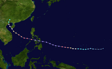
 Track of Typhoon Haiyan (Yolanda) | |
| Meteorological history | |
|---|---|
| Formed | November 3, 2013 |
| Dissipated | November 11, 2013 |
| Violent typhoon | |
| 10-minute sustained (JMA) | |
| Highest winds | 230 km/h (145 mph) |
| Lowest pressure | 895 hPa (mbar); 26.43 inHg |
| Category 5-equivalent super typhoon | |
| 1-minute sustained (SSHWS/JTWC) | |
| Highest winds | 315 km/h (195 mph) |
| Lowest pressure | 895 hPa (mbar); 26.43 inHg |
| Overall effects | |
| Areas affected | |
| History
Response Other wikis | |
Typhoon Haiyan's meteorological history began with its origins as a tropical disturbance east-southeast of Pohnpei and lasted until its degeneration as a tropical cyclone over southern China. The thirteenth typhoon of the 2013 Pacific typhoon season, Haiyan originated from an area of low pressure several hundred kilometers east-southeast of Pohnpei in the Federated States of Micronesia on November 2. Tracking generally westward, environmental conditions favored tropical cyclogenesis and the system developed into a tropical depression the following day. After becoming a tropical storm and attaining the name Haiyan at 0000 UTC on November 4, the system began a period of rapid intensification that brought it to typhoon intensity by 1800 UTC on November 5. By November 6, the Joint Typhoon Warning Center (JTWC) assessed the system as a Category 5-equivalent super typhoon on the Saffir–Simpson hurricane wind scale; the storm passed over the island of Kayangel in Palau shortly after attaining this strength.
Thereafter, it continued to intensify; at 12:00 UTC on November 7, the Japan Meteorological Agency (JMA) upgraded the storm's maximum ten-minute sustained winds to 230 km/h (64 m/s; 140 mph), the highest in relation to the cyclone. At 1800 UTC, the JTWC estimated the system's one-minute sustained winds to 315 km/h (88 m/s; 196 mph), unofficially making Haiyan the fourth most intense tropical cyclone ever observed. Several hours later, the eye of the cyclone made its first landfall in the Philippines at Guiuan, Eastern Samar, with an intensity of 305 km/h (85 m/s; 190 mph). This ties it with Typhoon Meranti as the second strongest landfall on record by maximum sustained 1-minute wind speeds, after Typhoon Goni. Gradually weakening, the storm made five additional landfalls in the country before emerging over the South China Sea. Turning northwestward, the typhoon eventually struck northern Vietnam as a severe tropical storm on November 10. Haiyan was last noted as a tropical depression by the JMA the following day.
© MMXXIII Rich X Search. We shall prevail. All rights reserved. Rich X Search
