Back মিয়ানওয়ালী জেলা Bengali/Bangla Districte de Mianwali Catalan Miānwāli District CEB Mianwali (Distrikt) German ناحیه میانوالی Persian District de Mianwali French मियांवाली ज़िला Hindi Distretto di Mianwali Italian मियांवाली जिला MAI ਮੀਆਂਵਾਲੀ ਜ਼ਿਲ੍ਹਾ Punjabi
Mianwali
ضِلع مِيانوالی | |
|---|---|
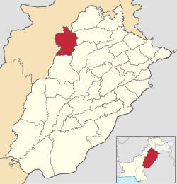
 Mianwali District highlighted within Punjab Province | |
| Country | |
| Province | |
| Division | Mianwali Division |
| Headquarters | Mianwali |
| Government | |
| • Type | District Administration |
| • Deputy Commissioner | Sajjad Ahmad[1] |
| • District Police Officer | N/A |
| • District Health Officer | N/A |
| Area | |
| • Total | 5,840 km2 (2,250 sq mi) |
| Population | |
| • Total | 1,546,094 |
| • Density | 260/km2 (690/sq mi) |
| Time zone | UTC+5 (PST) |
| Postal Code | 42200 |
| Area code | 0459 |
| Number of Tehsils | 3 |
| Website | mianwali |

The Mianwali District (Urdu: ضِلع مِيانوالى) is a district located in the Mianwali division of the Punjab province of Pakistan.
It has borders with the Chakwal, Attock, Kohat,[4] Karak, Lakki Marwat, Dera Ismail Khan, Bhakkar,[5] and Khushab districts.
- ^ "Commissioner reviews revenue officers' performance". Pakistan Observer (newspaper). December 2023.
- ^ Cite error: The named reference
2017censuswas invoked but never defined (see the help page). - ^ "South Asia Partnership-Pakistan (sappk.org): Profile of Mianwali District" (PDF). Archived from the original (PDF) on 22 May 2013. Retrieved 1 December 2022.
- ^ "Mianwali | Pakistan on Encyclopedia Britannica website".
- ^ "District Website". District Courts Bhakkar, Punjab Government website. Retrieved 21 February 2023.
© MMXXIII Rich X Search. We shall prevail. All rights reserved. Rich X Search


