Back مقاطعة موفات (كولورادو) Arabic موفات بؤلگهسی، کولورادو AZB Moffat County, Colorado BAR Мофат (акруга) Byelorussian Мофат (окръг) Bulgarian মোফ্ফাট কাউন্টি, কলোরাডো BPY Moffat Gông (Colorado) CDO Моффат (гуо, Колорадо) CE Moffat County CEB Moffat County Czech
Moffat County | |
|---|---|
 Round Bottom Area in Moffat County, Colorado | |
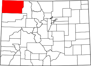
 Location within the U.S. state of Colorado | |
 Colorado's location within the U.S. | |
| Coordinates: 40°37′N 108°12′W / 40.61°N 108.2°W | |
| Country | |
| State | |
| Founded | February 27, 1911 |
| Named for | David H. Moffat |
| Seat | Craig |
| Largest city | Craig |
| Area | |
| • Total | 4,751 sq mi (12,310 km2) |
| • Land | 4,743 sq mi (12,280 km2) |
| • Water | 7.6 sq mi (20 km2) 0.2% |
| Population (2020) | |
| • Total | 13,292 |
| • Density | 2.8/sq mi (1.1/km2) |
| Time zone | UTC−7 (Mountain) |
| • Summer (DST) | UTC−6 (MDT) |
| Congressional district | 3rd |
| Website | moffatcounty |
Moffat County is a county located in the U.S. state of Colorado. As of the 2020 census, the population was 13,292.[1] The county seat is Craig.[2] With an area of 4,751 square miles, it is the second-largest county by area in Colorado, behind Las Animas County.
Moffat County comprises the Craig, CO, Micropolitan Statistical Area, which is also included in the Steamboat Springs–Craig, CO, Combined Statistical Area.
- ^ "State & County QuickFacts". United States Census Bureau. Retrieved September 5, 2021.
- ^ "Find a County". National Association of Counties. Retrieved June 7, 2011.
© MMXXIII Rich X Search. We shall prevail. All rights reserved. Rich X Search