Back مقاطعة مونرو (إلينوي) Arabic Monroe County, Illinois BAR Манро (акруга, Ілінойс) Byelorussian Монро (окръг, Илинойс) Bulgarian মনরৌ কাউন্টি, ইলিনয়স BPY Monroe Gông (Illinois) CDO Монро (гуо, Иллинойс) CE Monroe County (kondado sa Tinipong Bansa, Illinois) CEB Monroe County, Illinois Welsh Monroe County (Illinois) German
Monroe County | |
|---|---|
 Monroe County Courthouse in Waterloo | |
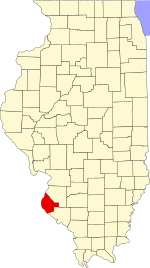
 Location within the U.S. state of Illinois | |
 Illinois's location within the U.S. | |
| Coordinates: 38°17′N 90°11′W / 38.28°N 90.18°W | |
| Country | |
| State | |
| Founded | 1816 |
| Named for | James Monroe |
| Seat | Waterloo |
| Largest city | Waterloo |
| Area | |
| • Total | 398 sq mi (1,030 km2) |
| • Land | 385 sq mi (1,000 km2) |
| • Water | 13 sq mi (30 km2) 3.3% |
| Population (2020) | |
| • Total | 34,962 |
| • Density | 88/sq mi (34/km2) |
| Time zone | UTC−6 (Central) |
| • Summer (DST) | UTC−5 (CDT) |
| Congressional district | 12th |
| Website | monroecountyil |
Monroe County is a county located in the U.S. state of Illinois. According to the 2020 census, it had a population of 34,962.[1] Its county seat and largest city is Waterloo.[2]
Monroe County is included in the St. Louis, MO-IL Metropolitan Statistical Area. It is located in the southern portion of Illinois known historically as "Little Egypt".
- ^ "State & County QuickFacts". United States Census Bureau.
- ^ "Find a County". National Association of Counties. Retrieved June 7, 2011.
© MMXXIII Rich X Search. We shall prevail. All rights reserved. Rich X Search


