Back مونتي بلاتا Arabic Monte Plata Catalan Monte Plata (munisipyo) CEB Monte Plata German Μόντε Πλάτα Greek Monte Plata Spanish مونته پلاتا Persian Monte Plata French Monte Plata Italian 몬테플라타 Korean
Monte Plata | |
|---|---|
 | |
| Coordinates: 18°48′36″N 69°47′24″W / 18.81000°N 69.79000°W | |
| Country | |
| Province | Monte Plata |
| Founded | 1606 |
| Area | |
| • Total | 623.55 km2 (240.75 sq mi) |
| Elevation | 56 m (184 ft) |
| Population (2012) | |
| • Total | 57,553 |
| • Density | 92/km2 (240/sq mi) |
| Municipal Districts | 3 |
| Distance to – Santo Domingo | 153 km |
| Climate | Af |
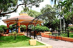
Monte Plata is a town and municipality (municipio) and the capital of the Monte Plata province in the Dominican Republic. It includes the municipal districts (distritos municipal) of Boyá, Chirino, and Don Juan.[3]
- ^ Superficies a nivel de municipios, Oficina Nacional de Estadistica Archived 2009-04-17 at the Wayback Machine
- ^ De la Fuente, Santiago (1976). Geografía Dominicana (in Spanish). Santo Domingo, Dominican Republic: Editora Colegial Quisqueyana.
- ^ "Listado de Codigos de Provincias, Municipio y Distritos Municipales, Actualizada a Junio 20 del 2006" (in Spanish). Oficina Nacional de Estadistica, Departamento de Cartografia, Division de Limites y Linderos. 20 June 2006. Archived from the original on 14 March 2007. Retrieved 12 August 2011.
© MMXXIII Rich X Search. We shall prevail. All rights reserved. Rich X Search

