Back Motueka (lungsod sa New Zealand) CEB Motueka German Motueka Spanish Motueka (ville) French Motueka Scots/Gaelic Motueka Malay Motueka Polish Мотуэка Russian موٹیوکا Urdu
Motueka | |
|---|---|
Town | |
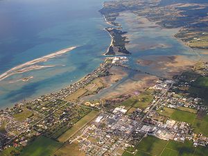
 An aerial view of Motueka looking east | |
| Nickname: "Mot" | |
 | |
| Coordinates: 41°07′24″S 173°00′53″E / 41.12333°S 173.01472°E | |
| Country | New Zealand |
| Territorial authority | Tasman |
| Ward | Motueka Ward |
| Community | Motueka Community[1] |
| Electorates | |
| Government | |
| • Territorial Authority | Tasman District Council |
| • Mayor of Tasman | Tim King |
| • West Coast-Tasman MP | Maureen Pugh |
| • Te Tai Tonga MP | Tākuta Ferris |
| Area | |
| • Total | 12.68 km2 (4.90 sq mi) |
| Population (June 2023)[3] | |
| • Total | 8,320 |
| • Density | 660/km2 (1,700/sq mi) |
| Time zone | UTC+12 (NZST) |
| • Summer (DST) | UTC+13 (NZDT) |
| Postal codes | 7120, 7196, 7197, 7198 |
| Area code | 03 |
| Website | www.lovemotueka.com |
Motueka is a town in the South Island of New Zealand, close to the mouth of the Motueka River on the western shore of Tasman Bay. It is the second largest in the Tasman Region, with a population of 8,320 as of June 2023.[3]
The surrounding district has a number of apple, pear, and kiwifruit orchards, as well as growing a variety of specialised crops such as hops. The area formerly served as the main centre of tobacco growing in New Zealand until the early 1980s.[4] A number of small vineyards have also been developed.
Nearby beaches (such as Kaiteriteri and Mārahau) are very popular with holidaymakers, and the area around Motueka has one of the country's highest annual sunshine-hour indices.[5] Riwaka lies 4.8 km north of Motueka via State Highway 60 and Nelson is 41.7 km to the east of Motueka via State Highway 60 and State Highway 6.
Motueka, as one of the nearest towns to the Abel Tasman and Kahurangi National Parks, has become the base of many tourism ventures, as well as in Nelson Lakes National Park, and in other recreational areas. Extensive limestone cave systems (including Harwoods Hole in the Tākaka Hill area north of Motueka) attract cavers and rock climbers. Sea kayaking, tramping, and canyoning now attract many thousands of visitors each year.
Many artists live in the area around Motueka, especially potters and reggae musicians. The Riverside Community, in nearby Lower Moutere, is a pacifist intentional community. Founded in the 1940s, it is New Zealand's oldest cooperative living community.[6]
- ^ "Motueka community board". www.tasman.govt.nz. Tasman District Council. Retrieved 11 July 2022.
- ^ Cite error: The named reference
Areawas invoked but never defined (see the help page). - ^ a b "Subnational population estimates (RC, SA2), by age and sex, at 30 June 1996-2023 (2023 boundaries)". Statistics New Zealand. Retrieved 25 October 2023. (regional councils); "Subnational population estimates (TA, SA2), by age and sex, at 30 June 1996-2023 (2023 boundaries)". Statistics New Zealand. Retrieved 25 October 2023. (territorial authorities); "Subnational population estimates (urban rural), by age and sex, at 30 June 1996-2023 (2023 boundaries)". Statistics New Zealand. Retrieved 25 October 2023. (urban areas)
- ^ "Motueka | NZHistory, New Zealand history online". nzhistory.govt.nz. Retrieved 26 January 2023.
- ^ "Total sunshine hours across selected New Zealand locations". Figure.NZ. Retrieved 16 September 2020.
- ^ "Riverside Community | Cooperative Living for Peace and Sustainability". Riverside.org.nz. Retrieved 14 July 2015.
© MMXXIII Rich X Search. We shall prevail. All rights reserved. Rich X Search