Back مولتونبورو (نيوهامشير) Arabic مولتونبورو ARZ Moultonborough Catalan Молтонборо (Нью-Гэмпшир) CE Moultonborough CEB Moultonborough, New Hampshire Welsh Moultonborough Spanish Moultonborough (New Hampshire) Basque Moultonborough French Moultonborough, New Hampshire HT
Moultonborough, New Hampshire | |
|---|---|
Town | |
 Swallow Boathouse in Moultonborough | |
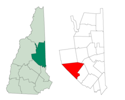
 Location in Carroll County, New Hampshire | |
| Coordinates: 43°45′18″N 71°23′47″W / 43.75500°N 71.39639°W | |
| Country | United States |
| State | New Hampshire |
| County | Carroll |
| Incorporated | 1777 |
| Villages |
|
| Government | |
| • Board of Selectmen |
|
| • Town Administrator | Charles F. Smith |
| Area | |
| • Total | 75.1 sq mi (194.5 km2) |
| • Land | 59.7 sq mi (154.6 km2) |
| • Water | 15.4 sq mi (39.9 km2) 20.50% |
| Elevation | 610 ft (186 m) |
| Population (2020)[2] | |
| • Total | 4,918 |
| • Density | 82/sq mi (31.8/km2) |
| Time zone | UTC-5 (Eastern) |
| • Summer (DST) | UTC-4 (Eastern) |
| ZIP code | 03254 |
| Area code | 603 |
| FIPS code | 33-49380 |
| GNIS feature ID | 0873671 |
| Website | www |
Moultonborough is a town in Carroll County, New Hampshire, United States. The population was 4,918 at the 2020 census,[2] up from 4,044 at the 2010 census.[3] Moultonborough is bounded in large part by Lake Winnipesaukee in the southwest and to a lesser extent by Squam Lake in the northwestern corner. The town includes the census-designated place of Suissevale and the community of Lees Mill.
- ^ "2021 U.S. Gazetteer Files – New Hampshire". United States Census Bureau. Retrieved November 1, 2021.
- ^ a b "Moultonborough town, Carroll County, New Hampshire: 2020 DEC Redistricting Data (PL 94-171)". U.S. Census Bureau. Retrieved November 1, 2021.
- ^ United States Census Bureau, American FactFinder, 2010 Census figures. Retrieved March 23, 2011.
© MMXXIII Rich X Search. We shall prevail. All rights reserved. Rich X Search
