Back جبل مونت ابراهام ARZ Mount Abraham (bukid sa Tinipong Bansa, Vermont) CEB ماؤنٹ ابراہیم (ورمونٹ) Urdu
| Mount Abraham | |
|---|---|
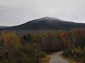
 View of Mount Abraham from the west | |
| Highest point | |
| Elevation | 4,006 ft (1,221 m)[1] |
| Prominence | 286 ft (87 m)[2] |
| Listing | New England 4,000 footers |
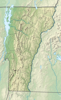
| Coordinates | 44°07′14″N 072°56′10″W / 44.12056°N 72.93611°W[3] |
| Geography | |
| Country | United States |
| State | Vermont |
| County | Addison |
| Town | Lincoln |
| Parent range | Presidential Range, Green Mountains |
| Topo map | USGS Lincoln Mountain Quad[4] |
Mount Abraham (known as Mount Abe to locals) is a mountain in the Green Mountains in the U.S. state of Vermont. Located in the Green Mountain National Forest, its summit is in the town of Lincoln in Addison County, but its eastern slopes extend into the town of Warren in Washington County. The mountain is named after Abraham Lincoln, former president of the United States.[5] It is one of five peaks in Vermont's Presidential Range.
At 4,006 feet (1,221.0 m), Mount Abraham is the highest point in Addison County, the fifth highest peak in Vermont, and one of the hundred highest peaks in New England. Its summit supports a small amount of alpine tundra vegetation.
- ^ Cite error: The named reference
GMC Long Trail mapwas invoked but never defined (see the help page). - ^ "Mount Abraham, Vermont". Peakbagger.com. Retrieved 2008-12-11.
- ^ Cite error: The named reference
GNISwas invoked but never defined (see the help page). - ^ Cite error: The named reference
USGS 1921was invoked but never defined (see the help page). - ^ Cite error: The named reference
Bushnell 2019was invoked but never defined (see the help page).
© MMXXIII Rich X Search. We shall prevail. All rights reserved. Rich X Search
