Back جبل مونت جريلوك ARZ Mount Greylock (bukid sa Tinipong Bansa, Massachusetts) CEB Mount Greylock German Mount Greylock Basque Mount Greylock Finnish Mont Greylock French Monte Greylock Italian Mount Greylock (Massachusetts) Polish ٹلہ گرےلاک PNB Грейлок Russian
| Mount Greylock | |
|---|---|
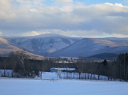
 Mt. Greylock seen from the West | |
| Highest point | |
| Elevation | 3,489 ft (1,063 m) NAVD 88[1] |
| Prominence | 2,463 ft (751 m)[2] |
| Listing | U.S. state high point 31st New England Fifty Finest 17th |
| Coordinates | 42°38′13″N 73°09′57″W / 42.63704°N 73.16593°W[1] |
| Geography | |
| Parent range | Taconic Mountains[3][4][5] |
| Geology | |
| Age of rock | Ordovician, Taconic orogeny |
| Mountain type | thrust fault |
| Climbing | |
| Easiest route | Cheshire Harbor Trail[6] |
Mount Greylock Summit Historic District | |
| Location | Jct. of Notch, Rockwell, and Summit Rds., Adams, Massachusetts |
|---|---|
| Area | 1,200 acres (490 ha)[8] |
| Built | 1830 |
| Architect | Maginnis and Walsh; Vance, Joseph MacArthur, et al. |
| Architectural style | Bungalow/Craftsman, Classical Revival |
| NRHP reference No. | 98000349[7] |
| Added to NRHP | April 20, 1998 |
Mount Greylock is the highest point in the state of Massachusetts at 3,489 feet (1,063 meters). Located in northwest region of the state, it is part of the Taconic Mountains, a geologically distinct range from the nearby Berkshires and Green Mountains. Expansive views and a small area of sub-alpine forest characterize its upper reaches. A seasonal automobile road crosses the summit area near three structures from the 1930s, which together constitute a small, "National Historic District." Various hiking paths including the Appalachian Trail traverse the area, which is part of the larger Mount Greylock State Reservation.[9]
The peak played a role in 19th century American literature,[10][11][12] and is featured in the work of Nathaniel Hawthorne, Herman Melville, and Henry David Thoreau.
- ^ a b "Greylock RM 1 Reset". NGS Data Sheet. National Geodetic Survey, National Oceanic and Atmospheric Administration, United States Department of Commerce.
- ^ "Mount Greylock, Massachusetts". Peakbagger.com.
- ^ Day Hiker's Guide to Vermont 5th ed. (2006). Green Mountain Club: Waterbury Center, Vermont
- ^ Raymo, Chet and Raymo, Maureen E. (1989). Written in Stone: A Geologic History of the Northeastern United States. Chester, Connecticut: Globe Pequot.
- ^ Doll, Charles G. Centennial Geologic Map of Vermont (1961). United States Geological Survey: Washington
- ^ "Suggested Day Hikes" (PDF). MassParks: Mount Greylock State Reservation. Executive Office of Energy and Environmental Affairs, Department of Conservation and Recreation. September 2011. Retrieved July 20, 2013.
- ^ "National Register Information System". National Register of Historic Places. National Park Service. March 13, 2009.
- ^ "Massachusetts, Berkshire County Historic Districts". National Register of Historic Places. American Dreams Inc. Retrieved January 6, 2011.
- ^ Cite error: The named reference
dcrwas invoked but never defined (see the help page). - ^ Shannon O’Brien. "Ilvermorny on Greylock". Today. Williams College, MA. Retrieved January 11, 2024.
- ^ Wetherell, W. D. (June 7, 1998). "Where Melville Paid Homage to a Mountain". The New York Times. ISSN 0362-4331. Retrieved January 11, 2024.
- ^ "How Western Massachusetts' Mount Greylock Became Inspiration For Literary Legends". www.wbur.org. November 17, 2016. Retrieved January 11, 2024.
© MMXXIII Rich X Search. We shall prevail. All rights reserved. Rich X Search
