Back غابة ماونت هود الوطنيه ARZ Mount Hood National Forest CEB Mount Hood National Forest German Bosque nacional Monte Hood Spanish جنگل ملی ماونت هود Persian Forêt nationale du Mont Hood French Mount Hood National Forest Dutch 胡德山国家森林 Chinese
| Mount Hood National Forest | |
|---|---|
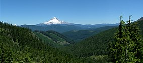
 Snow-covered Mount Hood in the Mount Hood National Forest | |
| Location | Oregon, U.S. |
| Nearest city | Government Camp, Oregon |
| Coordinates | 45°22′14″N 121°42′14″W / 45.37056°N 121.70389°W |
| Area | 1,071,466 acres (4,336.07 km2)[1] |
| Established | July 1, 1908[2] |
| Visitors | 4.4 million[3] (in 2006) |
| Governing body | U.S. Forest Service |
| Website | Mount Hood National Forest |
The Mount Hood National Forest is a U.S. National Forest in the U.S. state of Oregon, located 62 miles (100 km) east of the city of Portland and the northern Willamette River valley. The Forest extends south from the Columbia River Gorge across more than 60 miles (97 km) of forested mountains, lakes and streams to the Olallie Scenic Area, a high lake basin under the slopes of Mount Jefferson. The Forest includes and is named after Mount Hood, a stratovolcano and the highest mountain in the state.
The Forest encompasses some 1,067,043 acres (4,318.17 km2).[4] Forest headquarters are located in Sandy, Oregon.

A 1993 Forest Service study estimated that the extent of old growth in the Forest was 345,300 acres (139,700 ha).[5] The Forest is divided into four separate districts – Barlow (with offices in Dufur), Clackamas River (Sandy), Hood River (Mount Hood-Parkdale), and Zigzag (Zigzag).
In descending order of land area, Mount Hood National Forest is located in parts of Clackamas, Hood River, Wasco, Multnomah, Marion, and Jefferson counties.[6]
- ^ "Land Areas of the National Forest System" (PDF). U.S. Forest Service. January 2012. Retrieved June 30, 2012.
- ^ "The National Forests of the United States" (PDF). ForestHistory.org. Retrieved July 30, 2012.
- ^ Revised Visitation Estimates - National Forest Service
- ^ "About Us". Mt. Hood National Forest. U.S. Forest Service. Retrieved 2007-09-06.
- ^ Bolsinger, Charles L.; Waddell, Karen L. (1993). Area of old-growth forests in California, Oregon, and Washington (PDF) (Report). United States Forest Service, Pacific Northwest Research Station. Resource Bulletin PNW-RB-197.
- ^ Table 6 - NFS Acreage by State, Congressional District and County - United States Forest Service - September 30, 2007
© MMXXIII Rich X Search. We shall prevail. All rights reserved. Rich X Search
