Back Msida Catalan L-Imsida (munisipyo sa Malta) CEB ئیمسیدا CKB Msida Czech Msida German Msida Esperanto Msida Spanish Msida Basque مسیدا Persian L-Imsida French
This article includes a list of general references, but it lacks sufficient corresponding inline citations. (May 2019) |
Msida
L-Imsida | |
|---|---|
 | |
| Motto: Novissima Surgo | |
 | |
| Coordinates: 35°53′52″N 14°29′22″E / 35.89778°N 14.48944°E | |
| Country | |
| Region | Eastern Region |
| District | Northern Harbour District |
| Borders | Birkirkara, Ħamrun, Gżira, Pietà, San Ġwann, Santa Venera, Ta' Xbiex |
| Government | |
| • Mayor | Margaret Baldacchino Cefai (PL) |
| Area | |
| • Total | 1.7 km2 (0.7 sq mi) |
| Population (Jan. 2019) | |
| • Total | 13,713 |
| • Density | 8,100/km2 (21,000/sq mi) |
| Demonym(s) | Misidjan (m), Misidjana (f), Misidjani (pl) |
| Time zone | UTC+1 (CET) |
| • Summer (DST) | UTC+2 (CEST) |
| Postal code | MSD |
| Dialing code | 356 |
| ISO 3166 code | MT-34 |
| Patron saint | St. Joseph |
| Day of festa | 1st Sunday after 16 July |

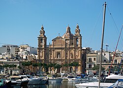
Msida (Maltese: L-Imsida, Italian: Misida) is a harbour town in the Eastern Region of Malta with a population of 7,623 (2021).[1]
- ^ "Population of Msida in 2020 2021 - statistics". all-populations.com. Retrieved 17 June 2021.
© MMXXIII Rich X Search. We shall prevail. All rights reserved. Rich X Search

