Back الحي الإسلامي (القدس) Arabic الحى المسلم ARZ Müsəlman məhəlləsi Azerbaijani মুসলিম মহল্লা (জেরুসালেম) Bengali/Bangla Muslimská Čtvrť (Jeruzalém) Czech Muslimisches Viertel von Jerusalem German Μουσουλμανική συνοικία της Ιερουσαλήμ Greek Barrio musulmán de Jerusalén Spanish Auzo musulmana (Jerusalem) Basque Jerusalemin muslimikortteli Finnish
Muslim Quarter
حارة المسلمين הרובע המוסלמי | |
|---|---|
Quarter | |
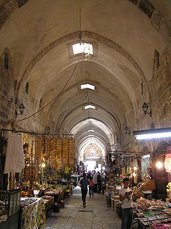
 Cotton market, reconstructed in 1336 by the Mamluk ruler Emir Tankiz, governor of Damascus | |
| Coordinates: 31°46′51″N 35°13′57″E / 31.78083°N 35.23250°E | |
| City | Old City of Jerusalem |
| Quarter | Muslim Quarter |
| Area | |
| • Total | 0.31 km2 (0.12 sq mi) |
| Population | |
| • Total | 22,000 |
| • Density | 70,968/km2 (183,810/sq mi) |
 | |
The Muslim Quarter (Arabic: حارة المسلمين, romanized: Ḥāraṫ al-Muslimīn; Hebrew: הרובע המוסלמי, romanized: Ha-Rovah ha-Muslemi) is one of the four sectors of the ancient, walled Old City of Jerusalem. It covers 31 hectares (77 acres) of the northeastern sector of the Old City.[1] The quarter is the largest and most populous of the four quarters and extends from the Lions' Gate in the east, along the northern wall of the Temple Mount in the south, to the Damascus Gate—Western Wall route in the west. The Via Dolorosa starts in this quarter.[2] The population of the Muslim Quarter is 22,000.[2]
- ^ The Holy Land, pg. 29.(This area excludes the Temple Mount which measures 35 acres)
- ^ a b Muslim Quarter of the "Old City" section of Jerusalem Archived 2012-12-20 at archive.today
© MMXXIII Rich X Search. We shall prevail. All rights reserved. Rich X Search
