KML is from Wikidata
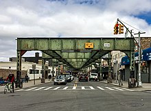
 The Myrtle Avenue Business Improvement District in Ridgewood | |
| Owner | City of New York |
|---|---|
| Maintained by | NYCDOT |
| Length | 8.1 mi (13.0 km)[1] |
| Location | Brooklyn, Queens |
| Nearest metro station | Jay Street Myrtle–Willoughby Avenues Myrtle Avenue Central Avenue Knickerbocker Avenue Myrtle–Wyckoff Avenues |
| West end | Duffield Street in Downtown Brooklyn |
| Major junctions | |
| East end | Jamaica Avenue in Richmond Hill |

Myrtle Avenue is a 8.1-mile-long (13.0 km) street that runs from Duffield Street in Downtown Brooklyn to Jamaica Avenue in Richmond Hill, Queens, in New York City, United States.[1] Myrtle is a main thoroughfare through the neighborhoods of Fort Greene, Clinton Hill, Bedford-Stuyvesant, Bushwick, Ridgewood, and Glendale.
- ^ a b Google (January 14, 2017). "Myrtle Avenue" (Map). Google Maps. Google. Retrieved January 14, 2017.
© MMXXIII Rich X Search. We shall prevail. All rights reserved. Rich X Search
