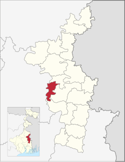
Nabadwip | |
|---|---|
Community development block | |
 | |
| Coordinates: 23°24′36″N 88°25′11″E / 23.4098934°N 88.4198570°E | |
| Country | |
| State | West Bengal |
| District | Nadia |
| Government | |
| • Type | Community development block |
| Area | |
| • Total | 97.39 km2 (37.60 sq mi) |
| Elevation | 15 m (49 ft) |
| Population (2011) | |
| • Total | 135,314 |
| • Density | 1,400/km2 (3,600/sq mi) |
| Languages | |
| • Official | Bengali, English |
| Literacy (2011) | |
| • Total literates | 81,116 (67.72%) |
| Time zone | UTC+5:30 (IST) |
| PIN | 741302 (Nabadwip) 741301 (Char Brahmanagar) 741507 (Majdia) 741313 (Mayapur) |
| Telephone/STD code | 03472 |
| Vehicle registration | WB-51, WB-52 |
| Lok Sabha constituency | Ranaghat |
| Vidhan Sabha constituency | Nabadwip |
| Website | nadia |
Nabadwip is a community development block that forms an administrative division in Krishnanagar Sadar subdivision of Nadia district in the Indian state of West Bengal.
© MMXXIII Rich X Search. We shall prevail. All rights reserved. Rich X Search
