Back نقلی، اوهایو AZB Негли (Огайо) CE Negley CEB Negley German Negley (Ohio) Spanish Negley (Ohio) Basque نگلی، اوهایو Persian Negley (Ohio) LLD Negley Polish Negley (Ohio) Portuguese
Negley, Ohio | |
|---|---|
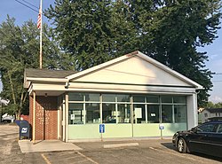
 Negley Post Office | |
 Location of Negley in Columbiana County and in the State of Ohio | |
| Coordinates: 40°47′34″N 80°32′09″W / 40.79278°N 80.53583°W | |
| Country | United States |
| State | Ohio |
| County | Columbiana |
| Township | Middleton |
| Area | |
| • Total | 0.90 sq mi (2.32 km2) |
| • Land | 0.90 sq mi (2.32 km2) |
| • Water | 0.00 sq mi (0.00 km2) |
| Elevation | 856 ft (261 m) |
| Population (2020) | |
| • Total | 274 |
| • Density | 305.80/sq mi (118.01/km2) |
| Time zone | UTC-5 (Eastern (EST)) |
| • Summer (DST) | UTC-4 (EDT) |
| ZIP code | 44441 |
| Area code(s) | 330, 234 |
| FIPS code | 39-53802 |
| GNIS feature ID | 2628937[2] |
| School District | East Palestine City School District |
Negley is an unincorporated community and census-designated place in Middleton Township, Columbiana County, Ohio, United States. The population was 274 at the 2020 census.[3] Historically a mining community, it lies at the confluence of Bull Creek and the North Fork of the Little Beaver Creek at the state border with Pennsylvania. State Routes 154 and 170 as well as the Youngstown and Southeastern Railroad pass through the community.
- ^ "ArcGIS REST Services Directory". United States Census Bureau. Retrieved September 20, 2022.
- ^ a b U.S. Geological Survey Geographic Names Information System: Negley, Ohio
- ^ "Negley CDP, Ohio". U.S. Census Bureau. Retrieved March 24, 2022.
© MMXXIII Rich X Search. We shall prevail. All rights reserved. Rich X Search