Back Nes aan de Amstel CEB Nes aan de Amstel Spanish نس آن آمستل Persian Nes-sur-l'Amstel French Nes aan de Amstel Dutch Нес-ан-де-Амстел Ukrainian Nes aan de Amstel ZH-MIN-NAN
Nes aan de Amstel | |
|---|---|
Village | |
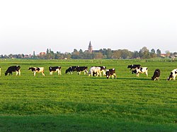
 View of Nes aan de Amstel | |
| Coordinates: 52°15′33″N 4°52′15″E / 52.25917°N 4.87083°E | |
| Country | Netherlands |
| Province | North Holland |
| Municipality | Amstelveen |
| Area | |
| • Total | 10.39 km2 (4.01 sq mi) |
| Elevation | −0.8 m (−2.6 ft) |
| Population (2021)[1] | |
| • Total | 985 |
| • Density | 95/km2 (250/sq mi) |
| Time zone | UTC+1 (CET) |
| • Summer (DST) | UTC+2 (CEST) |
| Postal code | 1189[1] |
| Dialing code | 020 |
| Website | nesaandeamstel.nl |
Nes aan de Amstel (Dutch pronunciation: [ˈnɛs aːn də ˈʔɑmstəl]) is a village in the municipality of Amstelveen in the province of North Holland, Netherlands. The village's name indicates that it is located on the Amstel; it is situated on the edge of the Rond Hoep polder.
- ^ a b c "Kerncijfers wijken en buurten 2021". Central Bureau of Statistics. Retrieved 28 April 2022.
- ^ "Postcodetool for 1189VK". Actueel Hoogtebestand Nederland (in Dutch). Het Waterschapshuis. Retrieved 28 April 2022.
© MMXXIII Rich X Search. We shall prevail. All rights reserved. Rich X Search

