Back 1.º distrito congresional de Nevada Spanish حوزه انتخابیه اول نوادا Persian Premier district congressionnel du Nevada French 1e congresdistrict van Nevada Dutch Nevada's 1st congressional district SIMPLE 內華達州第一國會選區 Chinese
| Nevada's 1st congressional district | |||
|---|---|---|---|
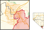
Interactive map of district boundaries since January 3, 2023 | |||
| Representative |
| ||
| Distribution |
| ||
| Population (2022) | 767,891 | ||
| Median household income | $63,781[1] | ||
| Ethnicity |
| ||
| Cook PVI | D+3[2] | ||
Nevada's 1st congressional district occupies parts of communities in Clark County east of the Las Vegas Freeway and south of Nellis Air Force Base, including parts of Las Vegas, most of Henderson, Paradise, Sunrise Manor, and Winchester, as well as all of Boulder City, Nelson, and Whitney. With a Cook Partisan Voting Index rating of D+3, it is the equal most Democratic districts in Nevada, along with the state’s 4th congressional district.[2]
Before the 1980 census, Nevada was represented by a single at-large congressional district. As a result of the redistricting cycle after the 1980 census, Nevada was split into two districts, due to its high population growth, relative to the rest of the country. From 1983 to 1993, the 1st district included most of Clark County. From 1993 to 2003, it covered most of the Las Vegas Valley, while the surrounding parts of Clark County (and the rest of the state) were in the 2nd district. Following the 2000 census, further population growth resulted in the creation of the 3rd congressional district, which included most of Henderson, North Las Vegas, Summerlin, and much of unincorporated Clark County. At the same time, the 1st district became smaller (and more population-dense), more urban, and more Democratic-leaning. It contracted even further after the 2010 census, which made it a majority-minority district; Hispanics now make up a plurality of its voters.
- ^ "My Congressional District".
- ^ a b "2022 Cook PVI: District Map and List". Cook Political Report. Retrieved January 10, 2023.
© MMXXIII Rich X Search. We shall prevail. All rights reserved. Rich X Search

