Back نيو ألباني Arabic نيو البانى (فلويد) ARZ نیو آلبانی، ایندیانا AZB Нью-Олбані Byelorussian Ню Олбани Bulgarian New Albany (Indiana) Catalan Нью-Олбани (Индиана) CE New Albany (kapital sa kondado sa Tinipong Bansa, Indiana) CEB New Albany, Indiana Welsh New Albany DAG
New Albany, Indiana | |
|---|---|
| City of New Albany | |
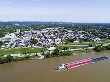
 New Albany as seen from the Ohio River. | |
 Location of New Albany in Floyd County, Indiana. | |
| Coordinates: 38°18′33″N 85°49′24″W / 38.30917°N 85.82333°W | |
| Country | United States |
| State | Indiana |
| County | Floyd |
| Government | |
| • Mayor | Jeff Gahan (D) |
| Area | |
| • Total | 15.64 sq mi (40.50 km2) |
| • Land | 15.47 sq mi (40.06 km2) |
| • Water | 0.17 sq mi (0.45 km2) |
| Elevation | 469 ft (143 m) |
| Population (2020) | |
| • Total | 37,841 |
| • Density | 2,446.72/sq mi (944.70/km2) |
| Time zone | UTC−5 (EST) |
| • Summer (DST) | UTC−4 (EDT) |
| ZIP codes | 47150-47151 |
| Area code(s) | 812 & 930 |
| FIPS code | 18-52326[3] |
| GNIS feature ID | 2395181[2] |
| Website | cityofnewalbany |

New Albany /ˈɑːlbəni/ is a city in Floyd County, Indiana, United States, situated along the Ohio River, opposite Louisville, Kentucky. The population was 37,841 as of the 2020 census.[4] The city is the county seat of Floyd County.[5] It is bounded by I-265 to the north and the Ohio River to the south, and is considered part of the Louisville, Kentucky Metropolitan Statistical Area. The mayor of New Albany is Jeff Gahan, a Democrat; he was re-elected in 2023.
- ^ "2020 U.S. Gazetteer Files". United States Census Bureau. Archived from the original on March 18, 2021. Retrieved March 16, 2022.
- ^ a b U.S. Geological Survey Geographic Names Information System: New Albany, Indiana
- ^ "U.S. Census website". United States Census Bureau. Archived from the original on July 9, 2021. Retrieved January 31, 2008.
- ^ "U.S. Census Bureau QuickFacts: New Albany city, Indiana". census.gov. Archived from the original on April 26, 2024. Retrieved June 28, 2022.
- ^ "Find a County". National Association of Counties. Archived from the original on May 31, 2011. Retrieved June 7, 2011.
© MMXXIII Rich X Search. We shall prevail. All rights reserved. Rich X Search

