| New Cut, Bristol | |
|---|---|
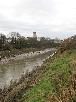
 The river Avon, in the New Cut, looking west towards Southville and St Pauls church, Bedminster | |
| Location | |
| Country | England |
| State | Bristol |
| Physical characteristics | |
| Source | River Avon |
| • location | Netham Weir, Bristol, England |
| • coordinates | 51°27′06″N 2°33′09″W / 51.45167°N 2.55250°W |
| • elevation | 27 ft (8.2 m) |
| Mouth | River Avon |
• location | Rownham, Bristol, England |
• coordinates | 51°26′53″N 2°37′30″W / 51.44806°N 2.62500°W |
• elevation | 9 ft (2.7 m) |
| Length | 3.2 mi (5.1 km) |
| Basin features | |
| Tributaries | |
| • left | River Malago |
The New Cut is an artificial waterway which was constructed between 1804 and 1809 to divert the tidal river Avon through south and east Bristol, England. This was part of the process of constructing Bristol's Floating Harbour, under the supervision of engineer William Jessop. The cut runs from Totterdown Basin at the eastern end of St Phillip's Marsh, near Temple Meads, to the Underfall sluices at Rownham in Hotwells and rejoining the original course of the tidal Avon.
The length of the cut is approximately 1.8 miles (2.9 km) and with the addition of short sections of the original course of the river Avon at either end, connecting Netham weir and Totterdown basin, and the Underfall sluices to the mouth of the Entrance lock at Cumberland Basin, the overall watercourse length is 3.2 miles (5.1 km). No ships have navigated the cut on a regular basis since the 1930s, but it is still possible for boats to proceed as far as Netham weir with care.[1]
- ^ Connolly, Sarah (3 September 2018). "Bristol ferry trip down the New Cut". Avon Stories. Retrieved 29 February 2024.
© MMXXIII Rich X Search. We shall prevail. All rights reserved. Rich X Search
