Back نونن (خيرفن آن نيدرفيتن) Arabic Nuenen, Gerwen en Nederwetten Catalan Gemeente Nuenen CEB Nuenen, Gerwen en Nederwetten Danish Nuenen, Gerwen en Nederwetten German Nuenen, Gerwen en Nederwetten Esperanto Nuenen, Gerwen en Nederwetten Spanish Nuenen, Gerwen en Nederwetten Basque نئونن، خرون اننیدروتن Persian Nuenen, Gerwen en Nederwetten Finnish
Nuenen, Gerwen en Nederwetten | |
|---|---|
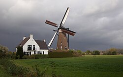
 Windmill De Roosdonck in Nuenen | |
 Location in North Brabant | |
| Coordinates: 51°29′N 5°33′E / 51.483°N 5.550°E | |
| Country | Netherlands |
| Province | North Brabant |
| Government | |
| • Body | Municipal council |
| • Mayor | Maarten Houben (CDA) |
| Area | |
| • Total | 33.94 km2 (13.10 sq mi) |
| • Land | 33.71 km2 (13.02 sq mi) |
| • Water | 0.23 km2 (0.09 sq mi) |
| Elevation | 16 m (52 ft) |
| Population (January 2021)[4] | |
| • Total | 23,702 |
| • Density | 703/km2 (1,820/sq mi) |
| Time zone | UTC+1 (CET) |
| • Summer (DST) | UTC+2 (CEST) |
| Postcode | 5670–5674 |
| Area code | 040 |
| Website | www |

Nuenen, Gerwen en Nederwetten (pronounced [ˈnynə(ŋ) ˈɣɛrʋə(n) ɛˌneːdərˈʋɛtə(n)] ) is a municipality consisting of the larger village of Nuenen and two adjacent smaller ones. It is located in the province of North Brabant, about 10 kilometres (6.2 mi) east of Eindhoven, the fifth largest city in the Netherlands. From being a small farmers town of less than 1000 inhabitants around 1950 Nuenen grew steadily as ever more new employees of Philips and the Eindhoven University (TUE) chose Nuenen as their new home.
- ^ "College van B en W" [Board of mayor and aldermen] (in Dutch). Gemeente Nuenen, Gerwen en Nederwetten. Archived from the original on 2 June 2014. Retrieved 2 June 2014.
- ^ "Kerncijfers wijken en buurten 2020" [Key figures for neighbourhoods 2020]. StatLine (in Dutch). CBS. 24 July 2020. Retrieved 19 September 2020.
- ^ "Postcodetool for 5671CK". Actueel Hoogtebestand Nederland (in Dutch). Het Waterschapshuis. Retrieved 2 June 2014.
- ^ "Bevolkingsontwikkeling; regio per maand" [Population growth; regions per month]. CBS Statline (in Dutch). CBS. 1 January 2021. Retrieved 2 January 2022.
© MMXXIII Rich X Search. We shall prevail. All rights reserved. Rich X Search
