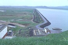
| O'Neill Dam | |
|---|---|
 O'Neill Forebay and Dam as seen from left bank. | |
| Official name | O'Neill Dam |
| Location | Merced County, California, U.S. |
| Coordinates | 37°04′50″N 121°02′50″W / 37.0805°N 121.0472°W |
| Construction began | 1963 |
| Opening date | 1967 |
| Operator(s) | US Bureau of Reclamation |
| Dam and spillways | |
| Impounds | San Luis Creek |
| Height | 87.5 ft (26.7 m) |
| Length | 14,300 ft (4,400 m) |
| Width (base) | 124 ft (38 m) |
| Reservoir | |
| Creates | O'Neill Forebay |
| Total capacity | 56,400 acre⋅ft (69,600 dam3) |
| Catchment area | 18 sq mi (47 km2) |
| Surface area | 2,250 acres (910 ha) |
| U.S. Geological Survey Geographic Names Information System: O'Neill Dam | |
O'Neill Dam is an earthfill dam on San Luis Creek, 12 miles (19 km) west of Los Banos, California, United States, on the eastern slopes of the Pacific Coast Ranges of Merced County. Forming the O'Neill Forebay, a forebay to the San Luis Reservoir, it is roughly 2.5 miles (4.0 km) downstream from the San Luis Dam.
© MMXXIII Rich X Search. We shall prevail. All rights reserved. Rich X Search
