This article needs additional citations for verification. (December 2012) |
| Occoquan Bay National Wildlife Refuge | |
|---|---|
IUCN category IV (habitat/species management area) | |
 | |
| Location | Prince William County, Virginia, United States |
| Nearest city | Woodbridge, Virginia |
| Coordinates | 38°38′39″N 77°14′09″W / 38.64417°N 77.23583°W |
| Area | 644 acres (261 ha) |
| Established | 1998 |
| Governing body | U.S. Fish and Wildlife Service |
| Website | Occoquan Bay National Wildlife Refuge |
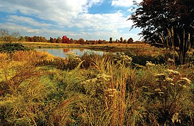
The Occoquan Bay National Wildlife Refuge is a National Wildlife Refuge located where the Occoquan River meets the Potomac River in Woodbridge, Virginia, United States between Belmont Bay and Occoquan Bay. The 644-acre (2.61 km2) site, about half of which is wetlands, was a popular tourist spot known as Dawson Beach until the 1940s, after which it was used for military research by the U.S. Army's Harry Diamond Laboratories from the 1960s to the 1990s.[1] When the land was purchased from the military, it was temporarily called the Marumsco National Wildlife Refuge. The refuge was formally established and renamed in 1998, and is now managed by the United States Fish and Wildlife Service as part of the Potomac River National Wildlife Refuge Complex.[2]
- ^ Waltemyer, T.A. (August 5, 1992). "A Compilation of Historical Notes Regarding the Woodbridge Research Facility, Woodbridge, Virginia" (PDF). Archived from the original (PDF) on September 27, 2011. Retrieved February 22, 2017.
- ^ "Occoquan Bay National Wildlife Refuge - About Us". United States Fish and Wildlife Service. Retrieved 2012-12-13.
© MMXXIII Rich X Search. We shall prevail. All rights reserved. Rich X Search


