Back Ocmulgee National Monument CEB Ocmulgee Mounds National Historical Park German Ocmulgee Mounds National Historical Park French Ocmulgee National Monument Italian Окмалги (национальный памятник) Russian Ocmulgee nationalmonument Swedish
| Ocmulgee Mounds National Historical Park | |
|---|---|
IUCN category V (protected landscape/seascape) | |
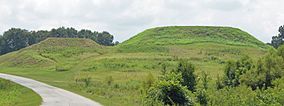
 The Great Temple Mound (right) and the Lesser Mound (left) | |
| Location | Macon, Georgia, USA |
| Coordinates | 32°50′12″N 83°36′30″W / 32.83667°N 83.60833°W |
| Area | 3,336 acres (13.50 km2)[1] |
| Established | December 23, 1936 |
| Visitors | 122,722 (in 2011)[2] |
| Governing body | National Park Service |
| Website | Ocmulgee Mounds National Historical Park |
| NRHP reference No. | 66000099[3] |
| Added to NRHP | October 15, 1966 |
Ocmulgee Mounds National Historical Park (formerly Ocmulgee National Monument) in Macon, Georgia, United States preserves traces of over ten millennia of culture from the Native Americans of the Southeastern Woodlands. Its chief remains are major earthworks built before 1000 CE by the South Appalachian Mississippian culture (a regional variation of the Mississippian culture.)[4] These include the Great Temple and other ceremonial mounds, a burial mound, and defensive trenches. They represented highly skilled engineering techniques and soil knowledge, and the organization of many laborers. The site has evidence of "12,000 years of continuous human habitation."[5] The 3,336-acre (13.50 km2) park is located on the east bank of the Ocmulgee River. Macon, Georgia developed around the site after the United States built Fort Benjamin Hawkins nearby in 1806 to support trading with Native Americans.
For thousands of years, succeeding cultures of prehistoric indigenous peoples had settled on what is called the Macon Plateau at the Fall Line, where the rolling hills of the Piedmont met the Atlantic coastal plain. The monument designation included the Lamar Mounds and Village Site, located downriver about three miles (4.8 km) from Macon. The site was designated for federal protection by the National Park Service (NPS) in 1934, listed on the National Register of Historic Places in 1966, and redesignated in 2019 as a national historical park.
- ^ "Listing of acreage – December 31, 2020" (XLSX). Land Resource Division, National Park Service. (National Park Service Acreage Reports)
- ^ "NPS Annual Recreation Visits Report". National Park Service. Retrieved May 14, 2012.
- ^ "National Register Information System". National Register of Historic Places. National Park Service. July 9, 2010.
- ^ "Southeastern Prehistory:Mississippian and Late Prehistoric Period". National Park Service. Retrieved April 10, 2012.
- ^ "Ocmulgee National Monument", National Park Service, accessed 15 July 2011
© MMXXIII Rich X Search. We shall prevail. All rights reserved. Rich X Search

