Back مقاطعة أونتاريو (نيويورك) Arabic Ontario County, New York BAR Онтарио (окръг, Ню Йорк) Bulgarian ওন্টারিও কাউন্টি, নিউ ইয়র্ক BPY Ontario Gông (New York) CDO Онтарио (гуо, Нью-Йорк) CE Ontario County CEB Ontario County Czech Ontario County, Efrog Newydd Welsh Ontario County German
42°51′N 77°17′W / 42.85°N 77.29°W
Ontario County | |
|---|---|
 Ontario County Courthouse in Canandaigua, 2014 | |
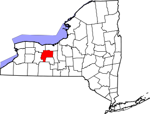
 Location within the U.S. state of New York | |
 New York's location within the U.S. | |
| Coordinates: 42°51′N 77°17′W / 42.85°N 77.29°W | |
| Country | |
| State | |
| Founded | 1789 |
| Named for | Lake Ontario |
| Seat | Canandaigua |
| Largest city | Geneva |
| Area | |
| • Total | 663 sq mi (1,720 km2) |
| • Land | 644 sq mi (1,670 km2) |
| • Water | 18 sq mi (50 km2) 2.8% |
| Population (2020) | |
| • Total | 112,458 |
| • Density | 169/sq mi (65/km2) |
| Time zone | UTC−5 (Eastern) |
| • Summer (DST) | UTC−4 (EDT) |
| Congressional district | 24th |
| Website | www |
Ontario County is a county in the U.S. State of New York. As of the 2020 census, the population was 112,458.[1] The county seat is Canandaigua.[2] The county is part of the Finger Lakes region of the state.
Ontario County is part of the Rochester, NY Metropolitan Statistical Area.
In 2006, Progressive Farmer rated Ontario County as the "Best Place to Live" in the U.S., for its "great schools, low crime, excellent health care" and its proximity to Rochester.
- ^ "U.S. Census Bureau QuickFacts: Ontario County, New York". United States Census Bureau. Retrieved January 2, 2022.
- ^ "Find a County". National Association of Counties. Retrieved June 7, 2011.
© MMXXIII Rich X Search. We shall prevail. All rights reserved. Rich X Search

