Back نهر اونتوناجون ARZ Ontonagon River (suba sa Tinipong Bansa, Michigan) CEB انتوناگون ریور Persian Ontonagon (rivière) French Онтуногун ревир Tajik
| Ontonagon River | |
|---|---|
 The Ontonagon River just below the confluence of its east and middle branches, as viewed from near US Highway 45 | |
 | |
| Etymology | Ojibwe Nondon-organ ("hunting river") or Ontonagori ("lost bowl")[1][2] |
| Physical characteristics | |
| Mouth | |
• location | Lake Superior |
• coordinates | 46°52′35″N 89°19′40″W / 46.87633°N 89.32791°W[3] |
| Type | Wild, Scenic, Recreational |
| Designated | March 3, 1992 |
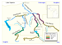
The Ontonagon River (/ˌɒntəˈnɑːɡən/ ON-tə-NAH-gən) is a river flowing into Lake Superior at the village of Ontonagon, on the western Upper Peninsula of Michigan in the United States. The main stem of the river is 25 miles (40 km) long[4] and is formed by a confluence of several longer branches, portions of which have been collectively designated as a National Wild and Scenic River.[5] Several waterfalls occur on the river including Agate Falls and Bond Falls.
- ^ Brothers, Hearne (July 11, 1970). "Michigan State". Hearne Brothers – via Google Books.
- ^ "The Land of Hiawatha: Upper Peninsula of Michigan". Upper Peninsula Development Bureau. July 11, 1928 – via Google Books.
- ^ "Ontonagon River". Geographic Names Information System. United States Geological Survey, United States Department of the Interior.
- ^ The American Rivers Outstanding Rivers List, Second Edition, May 1991. Compiled and edited by Matthew H. Huntington and John D. Echeverria. Washington, DC: American Rivers, Inc.
- ^ "Rivers (U.S. National Park Service)". www.nps.gov.
© MMXXIII Rich X Search. We shall prevail. All rights reserved. Rich X Search