| Paddington Brisbane, Queensland | |||||||||||||||
|---|---|---|---|---|---|---|---|---|---|---|---|---|---|---|---|
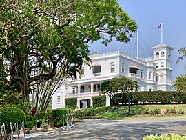
 Queensland's Government House, located at 170 Fernberg Road, Paddington, Brisbane, Queensland, Australia | |||||||||||||||
 | |||||||||||||||
| Coordinates | 27°27′34″S 153°00′04″E / 27.4594°S 153.0011°E | ||||||||||||||
| Population | 9,063 (2021 census)[1] | ||||||||||||||
| • Density | 3,630/km2 (9,390/sq mi) | ||||||||||||||
| Postcode(s) | 4064 | ||||||||||||||
| Area | 2.5 km2 (1.0 sq mi) | ||||||||||||||
| Time zone | AEST (UTC+10:00) | ||||||||||||||
| Location | 4.6 km (3 mi) WNW of Brisbane CBD | ||||||||||||||
| LGA(s) | City of Brisbane (Paddington Ward)[2] | ||||||||||||||
| State electorate(s) | |||||||||||||||
| Federal division(s) | |||||||||||||||
| |||||||||||||||
Paddington is an inner suburb in the City of Brisbane, Queensland, Australia.[3] In the 2021 census, Paddington had a population of 9,063 people.[1]
Paddington is located 4.6 kilometres (2.9 mi) west of the Brisbane CBD, by car. As is common with other suburbs in the area, Paddington is located on a number of steep ridges and hills. It was settled in the 1860s. Many original and distinctive Queenslander homes can be found in the suburb. Houses are frequently built on stumps, owing to the steep nature of their blocks.
Paddington includes the neighbourhood of Rosalie, which has its centre at the junction of Baroona Road and Nash Street (27°27′58″S 152°59′49″E / 27.4661°S 152.9969°E) and was a separate suburb until 1975.[4]
- ^ a b Cite error: The named reference
Census2021was invoked but never defined (see the help page). - ^ "Paddington Ward". Brisbane City Council. Archived from the original on 12 March 2017. Retrieved 12 March 2017.
- ^ "Paddington – suburb in City of Brisbane (entry 49851)". Queensland Place Names. Queensland Government. Retrieved 26 January 2020.
- ^ Cite error: The named reference
:1was invoked but never defined (see the help page).
© MMXXIII Rich X Search. We shall prevail. All rights reserved. Rich X Search

