Back جبل بانامنت Arabic جبل بانامنت ARZ Панаминт Рейндж Bulgarian Panamint Range CEB Panamint Range Czech Panamint Range German Chaînon Panamint French पैनामिंट श्रेणी Hindi パナミント山脈 Japanese Panamint Range Dutch
| Panamint Range | |
|---|---|
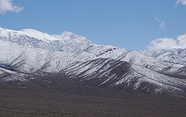
 Panamint Range looking toward Telescope Peak | |
| Highest point | |
| Peak | Telescope Peak |
| Elevation | 11,043 ft (3,366 m) NAVD 88[1] |
| Coordinates | 36°10′11″N 117°05′21″W / 36.169815947°N 117.089198336°W[1] |
| Geography | |
| Country | United States |
| State | California |
| District | Inyo County |
| Range coordinates | 36°10′11.8″N 117°5′21.2″W / 36.169944°N 117.089222°W[2] |
| Topo map | USGS Telescope Peak |
The Panamint Range is a short rugged fault-block mountain range in the northern Mojave Desert, within Death Valley National Park in Inyo County, eastern California. Dr. Darwin French is credited as applying the term Panamint in 1860 during his search for the fabled Gunsight Lode.[3] The orographic identity has been liberally applied for decades to include other ranges.
The origin of the name is the Paiute or Koso word Panümünt or Pa (water) and nïwïnsti (person).[4][5]
- ^ a b "Telescope". NGS Data Sheet. National Geodetic Survey, National Oceanic and Atmospheric Administration, United States Department of Commerce. Retrieved 2022-09-18.
- ^ "Panamint Range". Geographic Names Information System. United States Geological Survey, United States Department of the Interior. Retrieved 2009-05-03.
- ^ Gudde, Erwin G. (1998). California place names : the origin and etymology of current geographical names (4th ed., rev. and enl. ed.). Berkeley: University of California Press. p. 102 & 280. ISBN 0520213165.
- ^ Gudde, Erwin G. (1998). California place names : the origin and etymology of current geographical names (4th ed., rev. and enl. ed.). Berkeley: University of California Press. p. 280. ISBN 0520213165.
- ^ Bryan, T. Scott (15 January 2015). The Explorer's Guide to Death Valley National Park. p. 22. ISBN 9781607323419.
© MMXXIII Rich X Search. We shall prevail. All rights reserved. Rich X Search
