Back جزر باراسيل Arabic Islles Paracel AST Парасельскія астравы Byelorussian Парацэльскія астравы BE-X-OLD Параселски острови Bulgarian প্যারাসেল দ্বীপপুঞ্জ Bengali/Bangla Inizi Paracel Breton Illes Paracel Catalan Paracel Islands CEB Paracelské ostrovy Czech
| Disputed islands | |||||||||||||||||
|---|---|---|---|---|---|---|---|---|---|---|---|---|---|---|---|---|---|
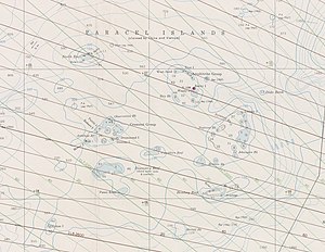
 Nautical chart of the Paracel Islands | |||||||||||||||||
| Geography | |||||||||||||||||
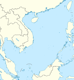
| Location | South China Sea | ||||||||||||||||
| Coordinates | 16°40′N 112°20′E / 16.667°N 112.333°E[1] | ||||||||||||||||
| Total islands | Over 30 | ||||||||||||||||
| Major islands | Woody, Rocky, Tree, Money, Robert, Pattle, Triton, Duncan, Lincoln, Drummond | ||||||||||||||||
| Area | 7.75 km2 (2.99 sq mi) (15,000 sq km ocean surface) | ||||||||||||||||
| Coastline | 518 km (321.9 mi) | ||||||||||||||||
| Highest elevation | 14 m (46 ft) | ||||||||||||||||
| Highest point | Rocky Island | ||||||||||||||||
| Administration | |||||||||||||||||
| Province | Hainan | ||||||||||||||||
| Prefecture-level city | Sansha | ||||||||||||||||
| District | Xisha District | ||||||||||||||||
| Claimed by | |||||||||||||||||
| Municipality | Kaohsiung | ||||||||||||||||
| Municipality | Da Nang | ||||||||||||||||
| Demographics | |||||||||||||||||
| Population | Over 1,000 (2014) | ||||||||||||||||
| Additional information | |||||||||||||||||
| Chinese name | |||||||||||||||||
| Simplified Chinese | 西沙群岛 | ||||||||||||||||
| Traditional Chinese | 西沙群島 | ||||||||||||||||
| Literal meaning | Western Sandy Archipelago | ||||||||||||||||
| |||||||||||||||||
| Vietnamese name | |||||||||||||||||
| Vietnamese | Quần đảo Hoàng Sa | ||||||||||||||||
| Hán-Nôm | 群島黃沙 | ||||||||||||||||
The Paracel Islands, also known as the Xisha Islands (simplified Chinese: 西沙群岛; traditional Chinese: 西沙群島; pinyin: xīshā qúndǎo; lit. 'West Sand Archipelago')[2] and the Hoàng Sa Archipelago (Vietnamese: Quần đảo Hoàng Sa, lit. 'Yellow Sand Archipelago'), are a disputed archipelago in the South China Sea currently under de facto administration by the People's Republic of China.
The word paracel is of Portuguese origin, meaning placer (a submerged bank or reef), and appears on 16th-century Portuguese maps. The archipelago includes about 130 small coral islands and reefs, most grouped into the northeastern Amphitrite Group or the western Crescent Group. They are distributed over a maritime area of around 15,000 square kilometers (5,800 sq mi), with a land area of approximately 7.75 square kilometers (2.99 sq mi). The archipelago is located about 220 miles (350 km) southeast of Hainan Island, equidistant from the coastlines of the People's Republic of China (PRC) and Vietnam, and approximately one-third of the way between central Vietnam and the northern Philippines.[3] A feature of the Paracel Islands is Dragon Hole, the second deepest blue hole (underwater sinkhole) in the world.[4][5][6] Sea turtles and seabirds are native to the islands, which have a hot and humid climate, abundant rainfall and may experience annual typhoons. The archipelago is surrounded by productive fishing grounds and a seabed containing potential, but still unexplored, oil and gas reserves.
- ^ Cite error: The named reference
ngawas invoked but never defined (see the help page). - ^ Jones, Gareth Wyn (2002). "Provinces". In Boland-Crewe, Tara; Lea, David (eds.). The Territories of the People's Republic of China. London: Europa Publications. p. 101. ISBN 978-0-203-40311-2.
- ^ "Paracel Islands". The World Factbook. CIA. Retrieved September 18, 2014.
- ^ "China Exclusive: South China Sea "blue hole" declared world's deepest". New China. news.xinhuanet.com. July 23, 2016. Archived from the original on July 24, 2016. Retrieved July 26, 2016.
- ^ "Researchers just discovered the world's deepest underwater sinkhole in the South China Sea". Washington Post. July 26, 2016. Archived from the original on July 27, 2016. Retrieved July 26, 2016.
- ^ Alcérreca-Huerta, Juan Carlos; Reyes-Mendoza, Oscar F.; Sánchez-Sánchez, Joan A.; Álvarez-Legorreta, Teresa; Carrillo, Laura (2024). "Recent records of thermohaline profiles and water depth in the Taam ja' Blue Hole (Chetumal Bay, Mexico)". Frontiers in Marine Science. 11: 1387235. doi:10.3389/fmars.2024.1387235.
Cite error: There are <ref group=lower-alpha> tags or {{efn}} templates on this page, but the references will not show without a {{reflist|group=lower-alpha}} template or {{notelist}} template (see the help page).
© MMXXIII Rich X Search. We shall prevail. All rights reserved. Rich X Search
