Back Ел Ретиро Bulgarian Parc del Retiro Catalan Parco del Buen Retiro CEB Park Retiro Czech Buen Retiro-parken Danish Retiro-Park German Πάρκο Μπουέν Ρετίρο Greek Parko Retiro Esperanto Parque del Retiro de Madrid Spanish Retiroko lorategiak Basque
| Retiro Park | |
|---|---|
| Parque del Buen Retiro | |
 | |
 | |
| Location | Madrid, Spain |
| Coordinates | 40°24′54″N 03°41′02″W / 40.41500°N 3.68389°W |
| Area | 142 hectares (350 acres) |
| Created | 1680 |
| Operated by | City Council of Madrid |
| Status | Public park |
| Criteria | Cultural: (ii), (iv), (vi) |
| Designated | 2021 (44th session) |
| Part of | Paseo del Prado and Buen Retiro, a landscape of Arts and Sciences |
| Reference no. | 1618 |
| Region | Europe and North America |
| Type | Non-movable |
| Criteria | Historic Garden |
| Designated | 8 February 1935 |
| Reference no. | RI-52-0000015 |
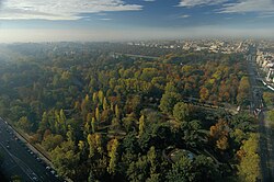
The Retiro Park (Spanish: Parque del Buen Retiro, literally "Good Retreat Park"), also known as Buen Retiro Park or simply El Retiro, is one of the largest city parks in Madrid, Spain. The park belonged to the Spanish monarchy until 1868, when it became a public park following the Glorious Revolution.
The park is located at the edge of the city centre, near both the Puerta de Alcalá and the Museo del Prado, and covers 1.4 km2 (350 acres). It has gardens, monuments, galleries, an artificial lake, and event-hosting venues.
In 2021, Buen Retiro Park became part of a combined UNESCO World Heritage Site that also includes Paseo del Prado.[1]
- ^ "UNESCO grants world heritage status to Madrid's Paseo del Prado and Retiro Park". Reuters. 25 July 2021. Archived from the original on 28 July 2021. Retrieved 28 July 2021.
© MMXXIII Rich X Search. We shall prevail. All rights reserved. Rich X Search