Back Penneshaw (lungsod) CEB Penneshaw Estonian پنشاو (استرالیای جنوبی) Persian Penneshaw (Sør-Australia) NB Penneshaw Polish Penneshaw Swedish
| Penneshaw South Australia | |||||||||||||||
|---|---|---|---|---|---|---|---|---|---|---|---|---|---|---|---|
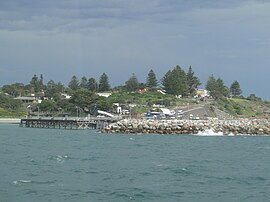
 Penneshaw harbour | |||||||||||||||
| Coordinates | 35°43′06″S 137°56′25″E / 35.71833°S 137.94028°E | ||||||||||||||
| Population | 276 (2011 census)[1] | ||||||||||||||
| Postcode(s) | 5222[2] | ||||||||||||||
| Time zone | ACST (UTC+9:30) | ||||||||||||||
| • Summer (DST) | ACDT (UTC+10:30) | ||||||||||||||
| Location | 107 km (66 mi) south of Adelaide | ||||||||||||||
| LGA(s) | Kangaroo Island Council | ||||||||||||||
| Region | Fleurieu and Kangaroo Island[3] | ||||||||||||||
| County | Carnarvon[4] | ||||||||||||||
| State electorate(s) | Mawson[5] | ||||||||||||||
| Federal division(s) | Mayo[6] | ||||||||||||||
| |||||||||||||||
| |||||||||||||||
| Footnotes | Location[2] Climate[7] Adjoining localities[4] | ||||||||||||||
Penneshaw is a township in the Australian state of South Australia located on the northeast coast of the Dudley Peninsula on Kangaroo Island about 107 kilometres (66 mi) south of the state capital of Adelaide.[4][2] It is the island's main ferry port with regular services from Cape Jervis. Penneshaw features a Maritime and Folk Museum, and evening tours to a colony of little penguin, the only species of penguin to breed in Australian waters. At the 2011 census, Penneshaw had a population of 276.[1]
Originally known as Hog Bay due to the pigs released by French Commander Nicholas Baudin, Penneshaw was named after a combination of the names of Dr. F.W.Pennefather,[8] private secretary to Governor Jervois, and Flora Louisa Shaw, The Times colonial editor, a visitor to Government House.[9]
South Australia's first modern seawater desalination plant was established at Penneshaw in the 1990s, to supplement the town's limited dam water supply.

- ^ a b Australian Bureau of Statistics (31 October 2012). "Penneshaw (State Suburb)". 2011 Census QuickStats. Retrieved 15 November 2015.
- ^ a b c "Postcode for Penneshaw, South Australia". postcodes-australia.com. Retrieved 19 January 2017.
- ^ "Fleurieu and Kangaroo Island SA Government region" (PDF). The Government of South Australia. Retrieved 9 September 2016.
- ^ a b c "Search result for "Penneshaw (LOCB)" (Record no SA0002275) with the following layers selected – "Suburbs and Localities"". Property Location Browser. Government of South Australia. Archived from the original on 12 October 2016. Retrieved 24 May 2016.
- ^ Mawson (Map). Electoral District Boundaries Commission. 2016. Retrieved 2 March 2018.
- ^ "Federal electoral division of Mayo, boundary gazetted 16 December 2011" (PDF). Australian Electoral Commission. Retrieved 2 August 2015.
- ^ "Monthly climate statistics: Summary statistics CAPE WILLOUGHBY (nearest station)". Commonwealth of Australia, Bureau of Meteorology. Retrieved 7 May 2016.
- ^ Adelaide University Prof Frederick William Pennefather LLM
- ^ Rodney Cockburn (1908) What's in a name? Nomenclature of South Australia: Fergusson Publications ISBN 0-9592519-1-X
© MMXXIII Rich X Search. We shall prevail. All rights reserved. Rich X Search
