| West Branch Pennsylvania Canal | |
|---|---|
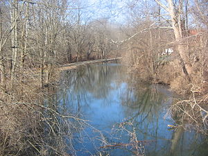
 Bald Eagle Crosscut Canal in Flemington in 2010 | |
 Map of historic Pennsylvania canals | |
| Location | |
| Country | United States |
| State | Pennsylvania |
| Physical characteristics | |
| Source | West Branch Susquehanna River |
| • location | Farrandsville, Clinton County |
| • coordinates | 41°10′12″N 77°30′57″W / 41.17000°N 77.51583°W[n 1] |
| • elevation | 558 ft (170 m)[1] |
| Mouth | Susquehanna River |
• location | Northumberland, Northumberland County |
• coordinates | 40°52′55″N 76°47′51″W / 40.88194°N 76.79750°W[2][n 2] |
• elevation | 420 ft (130 m)[3] |
| Length | 73 mi (117 km) |
| Basin features | |
| River system | Pennsylvania Canal |
| Original owner | Commonwealth of Pennsylvania |
The West Branch Division of the Pennsylvania Canal ran 73 miles (117 km) from the canal basin at Northumberland, Pennsylvania, at the confluence of the West Branch Susquehanna River with the main stem of the Susquehanna River, north through Muncy, then west through Williamsport, Jersey Shore, and Lock Haven to its terminus in Farrandsville.[4] At its southern terminus in the Northumberland basin, the West Branch Canal met the North Branch Canal and the Susquehanna Division Canal. Through these connections to other divisions of the Pennsylvania Canal, it formed part of a multi-state water transportation system including the Main Line of Public Works.[5]
Between Northumberland and Muncy, the canal lay east of the river. Beyond Muncy, where the river makes a right-angle turn, the canal lay to the north. Started in 1828 and completed in 1835, it had 19 lift locks overcoming a total vertical rise of about 140 feet (43 m).[4] The locks, beginning with No. 13, slightly upstream of the Northumberland Canal Basin, and ending with No. 34 at Lockport, across the river from Lock Haven, included two guard locks and an outlet lock in addition to the 19 lift locks.[6]
The state intended to extend the West Branch Canal from Farrandsville further upstream along the West Branch Susquehanna River to the mouth of Sinnemahoning Creek. Plans called for 33 miles (53 km) of canal, but the project was abandoned along with the idea that the West Branch Canal would eventually connect to the Allegheny River in western Pennsylvania.[7]
- ^ a b "Lick Run". Geographic Names Information System (GNIS). United States Geological Survey. August 2, 1979. Retrieved March 27, 2010.
- ^ Cite error: The named reference
gnis Northumberlandwas invoked but never defined (see the help page). - ^ a b "West Branch Susquehanna River". Geographic Names Information System. United States Geological Survey. August 2, 1979. Retrieved March 27, 2010.
- ^ a b Cite error: The named reference
Shank 52-53was invoked but never defined (see the help page). - ^ Shank, pp. 49–56
- ^ Shank, p.116
- ^ McCullough and Leuba, pp. 77–78
Cite error: There are <ref group=n> tags on this page, but the references will not show without a {{reflist|group=n}} template (see the help page).
© MMXXIII Rich X Search. We shall prevail. All rights reserved. Rich X Search
