Back بينولا Arabic بينولا ARZ Penola (lungsod) CEB Penola German پنولا، استرالیای جنوبی Persian Penola French Penola Italian Penola NB Penola Polish Penola (ort) Swedish
| Penola South Australia | |||||||||||||||
|---|---|---|---|---|---|---|---|---|---|---|---|---|---|---|---|
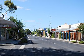
 Penola town centre | |||||||||||||||
| Coordinates | 37°22′43″S 140°50′10″E / 37.378605°S 140.83623°E[1] | ||||||||||||||
| Population |
| ||||||||||||||
| Established | 1867 (town) 13 December 2001 (locality)[1][4] | ||||||||||||||
| Postcode(s) | 5277 | ||||||||||||||
| Elevation | 65 m (213 ft) | ||||||||||||||
| Time zone | ACST (UTC+9:30) | ||||||||||||||
| • Summer (DST) | ACST (UTC+10:30) | ||||||||||||||
| Location | 388 km (241 mi) SE of Adelaide | ||||||||||||||
| LGA(s) | Wattle Range Council | ||||||||||||||
| Region | Limestone Coast[5] | ||||||||||||||
| County | Grey[1] | ||||||||||||||
| State electorate(s) | Mackillop[6] | ||||||||||||||
| Federal division(s) | Barker[7] | ||||||||||||||
| |||||||||||||||
| |||||||||||||||
| Footnotes | Adjoining localities[1][8][9] | ||||||||||||||
Penola (/pəˈnoʊlə/ pə-NOH-lə) is a town in the Australian state of South Australia located about 388 kilometres (241 mi) southeast of the state capital of Adelaide in the wine growing area known as the Coonawarra. At the 2021 Australian Census, the town of Penola had a population of 1,376. [10]
It is known as the central location in the life of Mary MacKillop (St Mary of the Cross), the first Australian to gain Roman Catholic sainthood, in 2010.[11] In 1866 McKillop and a Catholic priest and geologist, Julian Tenison-Woods, established a Catholic school in the town.
- ^ a b c d "Search result for 'Meningie, Locb' with the following datasets selected – 'Suburbs and Localities', 'Government Towns', 'Counties', 'Hundreds', 'Local Government Areas', 'SA Government Regions', 'Gazetteer', 'Railways' and 'State Maintained Roads'". Location SA Map viewer. Government of South Australia. Retrieved 11 April 2019.
- ^ "Penola 2021 Census". Retrieved 2 August 2023.
- ^ "Penola 2021 Census". Retrieved 2 August 2023.
- ^ Lawson, R. (13 December 2001). "GEOGRAPHICAL NAMES ACT 1991 Notice to Assign Boundaries and Names to Places (in the Wattle Range Council)" (PDF). The South Australian Government Gazette. South Australian Government. p. 5365. Retrieved 27 February 2018.
- ^ "Limestone Coast SA Government region" (PDF). The Government of South Australia. Retrieved 10 October 2014.
- ^ "District of Mackillop profile". Electoral Commission SA. Retrieved 9 April 2019.
- ^ "Federal electoral division of Barker" (PDF). Australian Electoral Commission. Retrieved 28 December 2017.
- ^ "West Wimmera Shire town and rural districts names and boundaries" (PDF). Locality names and boundary maps. Department of Environment, Land, Water and Planning, State Government of Victoria, Australia. Archived from the original (PDF) on 18 October 2015. Retrieved 5 September 2016.
- ^ "Glenelg Shire town and rural districts names and boundaries" (PDF). Locality names and boundary maps. Department of Environment, Land, Water and Planning, State Government of Victoria, Australia. Archived from the original (PDF) on 22 December 2016. Retrieved 3 September 2016.
- ^ "Penola 2021 Census". Retrieved 2 August 2023.
- ^ Thorpe, Osmund, "Cultural Advice", Australian Dictionary of Biography, Canberra: National Centre of Biography, Australian National University, retrieved 21 July 2021
© MMXXIII Rich X Search. We shall prevail. All rights reserved. Rich X Search
