Back Полинезийско мореплаване Bulgarian Navegació polinèsia Catalan Polynesisk navigation Danish Navegación polinesia Spanish ניווט בפולינזיה HE Őskori polinéziai navigáció Hungarian Navigasi Polinesia ID ウェイファインディング Japanese Polynesische navigatie Dutch Polynesian navigation SIMPLE


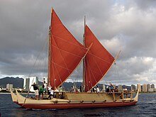
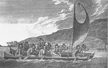
Polynesian navigation or Polynesian wayfinding was used for thousands of years to enable long voyages across thousands of kilometres of the open Pacific Ocean. Polynesians made contact with nearly every island within the vast Polynesian Triangle, using outrigger canoes or double-hulled canoes. The double-hulled canoes were two large hulls, equal in length, and lashed side by side. The space between the paralleled canoes allowed for storage of food, hunting materials, and nets when embarking on long voyages.[1] Polynesian navigators used wayfinding techniques such as the navigation by the stars, and observations of birds, ocean swells, and wind patterns, and relied on a large body of knowledge from oral tradition.[2][3][4][5] This island hopping was a solution to the scarcity of useful resources, such as food, wood, water, and available land, on the small islands in the Pacific Ocean. When an island’s required resources for human survival began to run low, the island's inhabitants used their maritime navigation skills and set sail for new islands. However, as an increasing number of islands in the South Pacific became occupied, and citizenship and national borders became of international importance, this was no longer possible. People thus became trapped on islands with the inability to support them.[6][7][8]
Navigators travelled to small inhabited islands using wayfinding techniques and knowledge passed by oral tradition from master to apprentice, often in the form of song. Generally, each island maintained a guild of navigators who had very high status; in times of famine or difficulty, they could trade for aid or evacuate people to neighbouring islands. As of 2014, these traditional navigation methods are still taught in the Polynesian outlier of Taumako in the Solomons and by voyaging societies throughout the Pacific.
Both wayfinding techniques and outrigger canoe construction methods have been kept as guild secrets, but in the modern revival of these skills, they are being recorded and published.
- ^ Bellwood, Peter (1978). The Polynesians Prehistory of an Island People. NY: Thames and Hudson. pp. 39. ISBN 978-0-500-02093-7.
- ^ Clark, Liesl (15 February 2000). "Polynesia's Genius Navigators". PBS. Retrieved 17 November 2016.
- ^ Bellwood, Peter (1978). The Polynesians Prehistory of an Island People. NY: Thames and Hudson. pp. 42. ISBN 978-0-500-02093-7.
- ^ Holmes, Lowell Don (1 June 1955). "Island Migrations (1): The Polynesian Navigators Followed a Unique Plan". XXV(11) Pacific Islands Monthly. Retrieved 1 October 2021.
- ^ Holmes, Lowell Don (1 August 1955). "Island Migrations (2): Birds and Sea Currents Aided Canoe Navigators". XXVI(1) Pacific Islands Monthly. Retrieved 1 October 2021.
- ^ Anderson, Atholl (January 2001). "No meat on that beautiful shore: the prehistoric abandonment of subtropical Polynesian islands". International Journal of Osteoarchaeology. 11 (1–2): 14–23. doi:10.1002/oa.542. ISSN 1047-482X.
- ^ Eckstein, Lars; Schwarz, Anja (2 January 2019). "The Making of Tupaia's Map: A Story of the Extent and Mastery of Polynesian Navigation, Competing Systems of Wayfinding on James Cook's Endeavour , and the Invention of an Ingenious Cartographic System". The Journal of Pacific History. 54 (1): 1–95. doi:10.1080/00223344.2018.1512369. ISSN 0022-3344.
- ^ Kirch, Patrick V. (1980). "Polynesian Prehistory: Cultural Adaptation in Island Ecosystems: Oceanic islands serve as archaeological laboratories for studying the complex dialectic between human populations and their environments". American Scientist. 68 (1): 39–48. ISSN 0003-0996. JSTOR 27849718.
© MMXXIII Rich X Search. We shall prevail. All rights reserved. Rich X Search