Back Port Macquarie-Hastings CEB Port Macquarie-Hastings Council German Conseil de Port Macquarie-Hastings French Municipalità di Port Macquarie - Hastings Italian Port Macquarie-Hastings Council Dutch Port Macquarie-Hastings Swedish
| Port Macquarie-Hastings New South Wales | |||||||||||||||
|---|---|---|---|---|---|---|---|---|---|---|---|---|---|---|---|
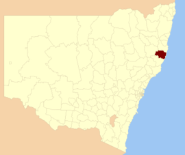
 Location in New South Wales | |||||||||||||||
| Coordinates | 31°26′S 152°54′E / 31.433°S 152.900°E | ||||||||||||||
| Population |
| ||||||||||||||
| • Density | 23.5376/km2 (60.9621/sq mi) | ||||||||||||||
| Established |
| ||||||||||||||
| Area | 3,686.1 km2 (1,423.2 sq mi) | ||||||||||||||
| Mayor | Peta Pinson (National)[3] | ||||||||||||||
| Council seat | Port Macquarie | ||||||||||||||
| Region | Mid North Coast | ||||||||||||||
| State electorate(s) | |||||||||||||||
| Federal division(s) | |||||||||||||||
 | |||||||||||||||
| Website | Port Macquarie-Hastings | ||||||||||||||
| |||||||||||||||
Port Macquarie-Hastings Council is a local government area in the Mid North Coast region of New South Wales, Australia.
The area is located adjacent to the Hastings River, the Pacific Highway, the Oxley Highway and the North Coast railway line. Major population centres in the local government area are Port Macquarie, Camden Haven, Wauchope, Lake Cathie and Kendall.
The mayor of the Port Macquarie-Hastings Council since 4 August 2017 is Cr. Peta Pinson, an independent politician who joined the Nationals in 2023.
- ^ Australian Bureau of Statistics (28 June 2022). "Port Macquarie-Hastings". 2021 Census QuickStats. Retrieved 11 December 2023.
- ^ "Regional population". Australian Bureau of Statistics. 20 April 2023. Retrieved 11 December 2023.
- ^ "PETA PINSON FOR PORT MACQUARIE - NSW Nationals". Retrieved 14 March 2023.
© MMXXIII Rich X Search. We shall prevail. All rights reserved. Rich X Search