Back بندر بریزبین Persian ブリスベン港 Japanese Port of Brisbane Dutch Port Brisbane Polish Porto de Brisbane Portuguese 布里斯本港 Chinese
| Port of Brisbane Brisbane, Queensland | |||||||||||||||
|---|---|---|---|---|---|---|---|---|---|---|---|---|---|---|---|
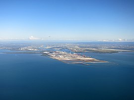
 Moreton Bay, the Port of Brisbane and Brisbane Airport, 2015 | |||||||||||||||
 | |||||||||||||||
| Coordinates | 27°22′49″S 153°10′49″E / 27.3802°S 153.1802°E | ||||||||||||||
| Population | 0 (2021 census)[1] | ||||||||||||||
| • Density | 0.000/km2 (0.00/sq mi) | ||||||||||||||
| Postcode(s) | 4178 | ||||||||||||||
| Area | 24.6 km2 (9.5 sq mi) | ||||||||||||||
| Time zone | AEST (UTC+10:00) | ||||||||||||||
| Location | 22 km (14 mi) from Brisbane CBD | ||||||||||||||
| LGA(s) | City of Brisbane (Wynnum Manly Ward)[2] | ||||||||||||||
| State electorate(s) | Lytton | ||||||||||||||
| Federal division(s) | Bonner | ||||||||||||||
| |||||||||||||||
Port of Brisbane is the shipping port and coastal suburb of the City of Brisbane, on the east coast of Queensland, Australia.[3] In the 2021 census, Port of Brisbane had "no people or a very low population".[1]
- ^ a b Cite error: The named reference
Census2021was invoked but never defined (see the help page). - ^ "Wynnum Manly Ward". Brisbane City Council. Archived from the original on 12 March 2017. Retrieved 12 March 2017.
- ^ "Port Of Brisbane – suburb in City of Brisbane (entry 47770)". Queensland Place Names. Queensland Government. Retrieved 26 December 2020.
© MMXXIII Rich X Search. We shall prevail. All rights reserved. Rich X Search
