The Kathmandu Valley (Nepali: काठमाडौं उपत्यका), also known as the Nepal Valley or Nepa Valley (Nepali: नेपाः उपत्यका, Nepal Bhasa: 𑐣𑐾𑐥𑐵𑑅 𑐐𑐵𑑅, नेपाः गाः), National Capital Area, is a bowl-shaped valley located in the Himalayan mountains of Nepal. It lies at the crossroads of ancient civilizations of the Indian subcontinent and the broader Asian continent, and has at least 130 important monuments, including several pilgrimage sites for Hindus and Buddhists. There are seven World Heritage Sites within the valley.
The Kathmandu Valley is the most developed and the largest urban agglomeration in Nepal with a population of about 5 million people. The urban agglomeration of Kathmandu Valley includes the cities of Kathmandu, Lalitpur, Bhaktapur, Changunarayan, Budhanilkantha, Tarakeshwar, Gokarneshwar, Suryabinayak, Tokha, Kirtipur, Madhyapur Thimi, and others. The majority of offices and headquarters are located in the valley, making it the economic hub of Nepal. It is popular with tourists for its unique architecture, and rich culture which includes the highest number of jatras (festivals) in Nepal. Kathmandu valley itself was referred to as "Nepal Proper" by British historians. As per the World Bank, the Kathmandu Valley was one of the fastest growing metropolitan areas in South Asia with 2.5 million population by 2010 and an annual growth rate of 4%. (Full article...)
This is a Good article, an article that meets a core set of high editorial standards.
Nepal sent a delegation to compete at the 2016 Summer Paralympics in Rio de Janeiro, Brazil, from 7–18 September 2016. This was the fourth time the nation had taken part in a Paralympic Games following its first appearance at the 2004 Summer Paralympics. Nepal was represented by two athletes in Rio de Janeiro: sprinter Bikram Rana and short-distance swimmer Laxmi Kunwar, who both qualified for the Paralympics by using wild card spots for their respective sports. Neither athlete advanced beyond the first round of their respective events as they both finished 17th overall in their competitions. (Full article...)
Newa cuisine (also referred to as Newar cuisine) is a subset of Nepalese cuisine that has developed over centuries among the Newars of Kathmandu (Kathmandu is called Yen in Nepal Bhasa) in Nepal. Newa cuisine is the most celebrated food variety in the country that consists of over 200 dishes. It is more elaborate than most Nepalese cuisines because the Kathmandu Valley has exceptionally fertile alluvial soil and enough wealthy households to make growing produce more profitable than cultivating rice and other staples.
Food is the integral part of Newar culture. Different kind of foods are prepared for different occasions, considering the climate and nutritional needs for body. Newars are renowned for their sumptuous feasting. Dishes served during feasts and festivals have symbolic significance. (Full article...)
The following pages at Wikimedia Commons contain a plethora of images taken in Nepal.
Wiki Loves Earth is an international photographic competition to promote natural heritage sites around the World through Wikimedia projects (mainly Wikipedia and Wikimedia Commons).
Wiki Loves Monuments is an international photographic competition to promote cultural monuments around the World through Wikimedia projects (mainly Wikipedia and Wikimedia Commons.
Image 12A map of Greater Nepal with the book published in 1819 by Francis Hamilton M. D. named "An Account of the Kingdom of Nepal and the Territories annexed to this Dominion by the House of Gorkha". (from History of Nepal)
Image 13A 1905 painting of Nepalese woman (from Culture of Nepal)
Image 14Women in cultural costume at Ubhauli Kirati festival 2017 at Gough Whitlam Park, Earlwood (from Culture of Nepal)
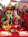
Image 15Procession of Nepali Hindu Wedding; Groom being carried by a bride brother or relatives (from Culture of Nepal)
This is a list of recognized content, updated weekly by JL-Bot (talk·contribs) (typically on Saturdays). There is no need to edit the list yourself. If an article is missing from the list, make sure it is tagged (e.g. {{WikiProject Nepal}}) or categorized correctly and wait for the next update. See WP:RECOG for configuration options.


.svg)


 Costumed Hindu girls of Kathmandu during festival time in Nepal (from Culture of Nepal)
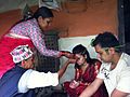 Senior offering Dashain Tika on great Nepali Hindu festival at a traditional home. (from Culture of Nepal)
 Mohar of king Prithvi Narayan Shah dated Saka Era 1685 (CE 1763) (from History of Nepal)
 "Nēpāla" in the late Brahmi script, in the Allahabad Pillar inscription of Samudragupta (350-375 CE). (from History of Nepal)
 Procession of Nepali Pahadi Hindu Wedding (from Culture of Nepal)
 A Buddhist monastery in southern Nepal. (from Culture of Nepal)
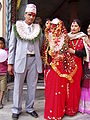 Nepali Pahadi Hindu marriage at Narayangadh, Chitawan (from Culture of Nepal)
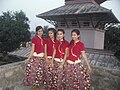 Nepali traditional Pahadi dress used for dance (from Culture of Nepal)
 Procession of Nepali Hindu Wedding (from Culture of Nepal)
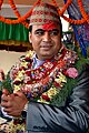 Nepali Pahadi groom (from Culture of Nepal)
 A map of Greater Nepal with the book published in 1819 by Francis Hamilton M. D. named "An Account of the Kingdom of Nepal and the Territories annexed to this Dominion by the House of Gorkha". (from History of Nepal)
 A 1905 painting of Nepalese woman (from Culture of Nepal)
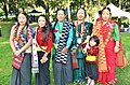 Women in cultural costume at Ubhauli Kirati festival 2017 at Gough Whitlam Park, Earlwood (from Culture of Nepal)
 Procession of Nepali Hindu Wedding; Groom being carried by a bride brother or relatives (from Culture of Nepal)
 Statue of the Bodhisattva Avalokiteshvara, gilded bronze, Nepal, 16th century CE (from Culture of Nepal)
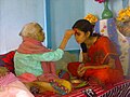 Senior offering Dashain Tika to junior (from Culture of Nepal)


.jpg)


.jpg)


.jpg)


_(restoration).jpg)


_4.jpg)
_(restoration).jpg)


,_male,_Gokarna.jpg)


.jpg)
.jpg)
 Commons
 Wikibooks
 Wikidata
 Wikinews
 Wikiquote
 Wikisource
 Wikiversity
 Wikivoyage
 Wiktionary


