| Portal | WikiProject Rivers | Talk page |
Introduction

A river is a natural flowing freshwater stream, flowing on land or inside caves towards another body of water at a lower elevation, such as an ocean, lake, or another river. A river may run dry before reaching the end of its course if it runs out of water, or only flow during certain seasons. Rivers are regulated by the water cycle, the processes by which water moves around the Earth. Water first enters rivers through precipitation, whether that be from the runoff of water down a slope, the melting of glaciers or snow, or seepage from aquifers beneath the surface of the Earth.
Rivers flow and merge together in confluences to form drainage basins, areas where all water eventually flows to a common outlet. Rivers have a great effect on the landscape around them. They may regularly overflow their banks and flood the surrounding area, spreading nutrients to the surrounding area. Sediment or alluvium carried by rivers shapes the landscape around it, forming deltas and islands where the flow slows down. Rivers rarely run in a straight line, instead they bend or meander; the locations of a river's banks can change frequently. Rivers get their alluvium from erosion, which serves to carve rock into canyons and valleys.
Rivers have sustained human and animal life for millennia, including the first human civilizations. The organisms that live around or in a river such as fish, aquatic plants, and insects have different roles, including processing organic matter and predation. Rivers have produced abundant resources for humans, including food, transportation, drinking water, and recreation. Humans have engineered rivers to prevent flooding, irrigate crops, perform work with water wheels, and produce hydroelectricity from dams. People associate rivers with life and fertility, and have strong religious, political, social, and mythological attachments to them. (Full article...)
Selected article -

Mud Creek is a tributary of Chillisquaque Creek in Columbia County and Montour County in Pennsylvania, in the United States. It is approximately 8.3 miles (13.4 km) long and flows through Madison Township, Columbia County and Derry Township, Montour County. The main tributaries of the creek are unnamed tributaries. The creek's watershed has an area of 17.70 square miles and is in West Hemlock Township, Montour County as well as the two townships it flows through. The watershed is mostly agricultural and forested and the main developed areas are Washingtonville and Jerseytown.
As of 2011, the daily load of sediment in Mud Creek is 24,165.59 pounds (10,961.33 kg) and the daily load of phosphorus is 16.64 pounds (7.55 kg). Various other compounds and metals are also found in the creek. The main rock formations in the watershed include the Hamilton Group, the Trimmers Rock Formation, and the Onondaga and Old Port Formations. The main soil series are the Watson-Berks-Alvira series, the Chenango-Pope-Holly series, and the Berks-Weikert-Bedington series. The watershed is in the ridge and valley region of the Appalachian Mountains. (Full article...)Selected Quote

Selected picture

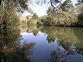
Dordogne in Perigord, south-western France, near Castelnaud-la-Chapelle
General images -
-
 A forest stream in the winter near Erzhausen, Germany (from River ecosystem)
 -
 Anthropogenic influences on river systems. Examples are mainly from settings with a modest technological influence, especially in the period of about 10,000 to 4000 cal yr BP. (from River ecosystem)
 -
 The brook trout is native to small streams, creeks, lakes, and spring ponds. (from River ecosystem)
 -
 The cave of source of the Buna can be entered by boat and dived through a cave system serving as an effluence of the Zalomka. (from Subterranean river)
 -
 In Dante's Inferno, Charon ferries souls across the subterranean river Acheron. (from Subterranean river)
 -
 Pondweed is an autochthonous energy source. (from River ecosystem)
 -
 New Zealand longfin eels can weigh over 50 kilograms. (from River ecosystem)
 -
 Different biofilm components in streams. Principal components are algae and bacteria. (from River ecosystem)
 -
 Common water hyacinth in flower (from River ecosystem)
 -

-
 A subterranean river in the Cross Cave system of Slovenia. (Scale shown by people in photograph.) (from Subterranean river)
 -
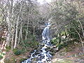 Cascade in the Pyrénées (from River ecosystem)
 -
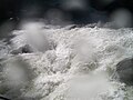 Whitewater at Yosemite (from Whitewater)
 -
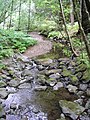 This stream operating together with its environment can be thought of as forming a river ecosystem. (from River ecosystem)
 -

-
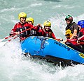 Rafting is a watersport where buoyancy aids, helmets and wetsuits are mandatory and often imposed by law, due to the constant risk of falling off the boat and into the rapids (from Whitewater)
 -
 Leaf litter is an allochthonous energy source. (from River ecosystem)
 -
 A pensive Cooplacurripa River, NSW (from River ecosystem)
 -
 Devil's Throat Cave subterranean river from above (from Subterranean river)
 -
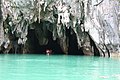 The Puerto Princesa cave can be entered by boat. (from Subterranean river)
 -
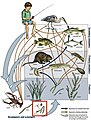 Example of a river food web. Bacteria can be seen in the red box at the bottom. Bacteria (and other decomposers, like worms) decompose and recycle nutrients back to the habitat, which is shown by the light blue arrows. Without bacteria, the rest of the food web would starve, because there would not be enough nutrients for the animals higher up in the food web. The dark orange arrows show how some animals consume others in the food web. For example, lobsters may be eaten by humans. The dark blue arrows represent one complete food chain, beginning with the consumption of algae by the water flea, Daphnia, which is consumed by a small fish, which is consumed by a larger fish, which is at the end consumed by the great blue heron. (from River ecosystem)
 -
 Rapids in Mount Robson Provincial Park (from River ecosystem)
 -
 The Effra is one of the subterranean rivers of London. It empties into the Thames by Vauxhall Bridge, from which this photograph was taken. (from Subterranean river)
 -
 Map of the world showing elevation levels (from Upland and lowland)
 -
 Periphyton (from River ecosystem)
 -
 Co-occurrence network of a bacterial community in a stream (from River ecosystem)
 -
 Flowing rivers can act as dispersal vectors for plant matter and invertebrates. (from River ecosystem)


.jpg)


.jpg)


Did you know?
- ... that 25 million tourists—more than twice the population of the entire state—visited the Mandakini River in Uttarakhand in 2011?
- ... that for three years, an illegal gold-mining settlement on the Amur river went on to host high-class hotels, have public healthcare, and even have a casino?
- ... that Boom Hall was named after a defensive structure on the River Foyle that was breached during the 1689 Siege of Derry?
Related portals
Selected Panorama

Topics
| Large-scale features | |
|---|---|
| Alluvial rivers | |
| Bedrock river | |
| Bedforms | |
| Regional processes | |
| Mechanics | |
Subcategories

Quality content
| This is a list of recognized content, updated weekly by JL-Bot (talk · contribs) (typically on Saturdays). There is no need to edit the list yourself. If an article is missing from the list, make sure it is tagged (e.g. {{WikiProject Rivers}}) or categorized correctly and wait for the next update. See WP:RECOG for configuration options. |
Featured articles
 Aliso Creek (Orange County)
- Balch Creek
- Big Butte Creek
- Bull Run River (Oregon)
- Chetco River
- Colorado River
- Columbia River
- Columbia Slough
- Fanno Creek
- Johnson Creek (Willamette River tributary)
- Jordan River (Utah)
- Little Butte Creek
- Plunketts Creek (Loyalsock Creek tributary)
- River Parrett
- Rogue River (Oregon)
- St. Johns River
- Tryon Creek
- Waterfalls in Ricketts Glen State Park
- White Deer Hole Creek
- Willamette River
Featured lists
- List of longest rivers of the United States (by main stem)
- List of longest streams of Idaho
- List of longest streams of Oregon
- List of tributaries of Bowman Creek
- List of tributaries of Catawissa Creek
- List of tributaries of Larrys Creek
- List of tributaries of Mahanoy Creek
- List of tributaries of Shamokin Creek
Good articles
 1886 St. Croix River log jam
- Abrahams Creek
- Adams River (British Columbia)
- River Avon, Bristol
- Big Wapwallopen Creek
- Black Creek (Susquehanna River tributary)
- Briar Creek (Susquehanna River tributary)
- Brunswick Falls
- Buffalo Creek (West Branch Susquehanna River tributary)
- Canajoharie Creek
- Catawissa Creek
- Celilo Falls
- Cem (river)
- Chollas Creek
- Cibolo Creek
- Covering of the Senne
- Darby Creek (Pennsylvania)
- Eddy Creek (Lackawanna River tributary)
- Esopus Creek
- Estuaries of Texas
- Everglades
- Fishing Creek (North Branch Susquehanna River tributary)
- Flushing River
- Fonteyn Kill
- Fossil Creek
- River Frome, Bristol
- Gowanus Canal
- Great Zab
- Hammersley Fork
- Harveys Creek
- Hudson River
- Hull Creek (Lackawanna River tributary)
- River Hull
- Hunlock Creek
- River Irwell
- Islais Creek
- Ithan Creek
- Jiloca (river)
- Kaweah River
- Kettle Creek (Pennsylvania)
- Keyser Creek
- Kings River (California)
- Kissena Creek
- Klamath River
- Kootenay River
- Laguna Canyon
- Leggetts Creek
- Little Applegate River
- Little Catawissa Creek
- Little Fishing Creek
- Little Wapwallopen Creek
- Mahanoy Creek
- Mahoning Creek (Susquehanna River tributary)
- Meadow Brook (Lackawanna River tributary)
- Merced River
- Messers Run
- Minetta Creek
- Minnehaha Park (Minneapolis)
- Missouri River
- Moston Brook
- Mud Creek (Chillisquaque Creek tributary)
- Muncy Creek
- Nanticoke Creek
- Neepaulakating Creek
- Nescopeck Creek
- Ombla
- Petitcodiac River
- Potlatch River
- River Arun
- River Brue
- River Tone
- River Torrens
- River Weaver
- Roaring Brook (Lackawanna River tributary)
- Roaring Creek (Pennsylvania)
- River Rother, East Sussex
- River Rother, West Sussex
- San Juan Creek
- Santa Ana River
- Sava
- Saw Mill River
- Scotch Run (Catawissa Creek tributary)
- Severn bore
- Shickshinny Creek
- Shimna River
- Shinano River
- Snake River
- Solomon Creek
- Spring Brook (Lackawanna River tributary)
- Stafford Meadow Brook
- Stanislaus River
- Stikine River
- Stony Brook (Charles River tributary, Boston)
- Sulphur Creek (California)
- Tangascootack Creek
- Toby Creek
- Trinity River (California)
- River Trym
- Twomile Run
- Wainui Falls
- River Welland
- West Branch Fishing Creek
- West Creek (Pennsylvania)
- West Kill
- River Witham
- Yellala Falls
- Zarqa River
Things to do

- Join WikiProject Rivers
- Help select future pictures and articles.
- Add items to Did You Know?
- Add the portal link to the top of the See Also section of all relevant pages. This can be done by adding
{{Portal|Rivers}}immediately under the section header.
Associated Wikimedia
The following Wikimedia Foundation sister projects provide more on this subject:
-
 Commons
Free media repository -
 Wikibooks
Free textbooks and manuals -
 Wikidata
Free knowledge base -
 Wikinews
Free-content news -
 Wikiquote
Collection of quotations -
 Wikisource
Free-content library -
 Wikiversity
Free learning tools -
 Wikivoyage
Free travel guide -
 Wiktionary
Dictionary and thesaurus
More portals


© MMXXIII Rich X Search. We shall prevail. All rights reserved. Rich X Search