Back Портал:Район на Санфранциския залив Bulgarian Portail:Région de la baie de San Francisco French
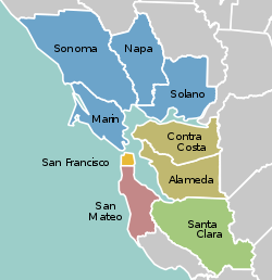
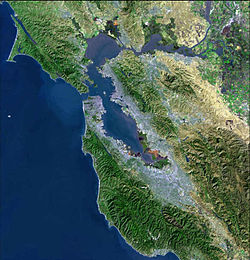
The San Francisco Bay Area Portal  The San Francisco Bay Area (referred to locally as the Bay Area) is a populous region surrounding the San Francisco and San Pablo estuaries in Northern California. The region encompasses the major cities and metropolitan areas of San Jose, San Francisco, and Oakland, along with smaller urban and rural areas. The Bay Area's nine counties are Alameda, Contra Costa, Marin, Napa, San Francisco, San Mateo, Santa Clara, Solano, and Sonoma. Home to approximately 7.68 million people, the nine-county Bay Area contains many cities, towns, airports, and associated regional, state, and national parks, connected by a network of roads, highways, railroads, bridges, tunnels, and commuter rail. The combined statistical area of the region is the second-largest in California (after the Greater Los Angeles area), the fifth-largest in the United States, and the 43rd-largest urban area in the world with 8.80 million people. The Bay Area has the second-most Fortune 500 companies in the United States, after the New York metropolitan area, and is known for its natural beauty, liberal politics, entrepreneurship, and diversity. The area ranks second in highest density of college graduates, after the Washington, D.C. metropolitan area and performs above the state median household income in the 2010 census; it includes the five highest California counties by per capita income and two of the top 25 wealthiest counties in the United States. Based on a 2013 population report from the California Department of Finance, the Bay Area is the only region in California where the rate of people migrating in from other areas in the United States is greater than the rate of those leaving the region, led by Alameda and Contra Costa counties. (more...) Selected article The cape protects Drakes Bay on its southern side. The headland is largely drained by Drakes Estero. Drakes Bay and Drake's Estero are named after English seafarer Sir Francis Drake who possibly hauled his ship, the Golden Hinde, up onto the beach for repairs in June 1579. Inverness Ridge runs along the peninsula's northwest-southeast spine, with forested peaks around 430 meters (1,400 ft). West of the ridge, the land flattens out and the vegetation turns to scrub. The Mount Vision fire in 1995 burned part of Inverness Ridge. Point Reyes lends its name to the town of Point Reyes Station, California. The point may once have been known as Lobes Lighthouse by the sailors of clipper ships on the meat trade. (more...) Selected biography Brown was born in Mineola, Texas and attended a segregated high school. He moved to San Francisco in 1951, attending San Francisco State University and graduating in 1955 with a degree in liberal studies. Brown earned a J.D. from University of California, Hastings College of the Law in 1958. He spent several years in private practice before gaining election in his second attempt to the California Assembly in 1964. Brown became the Democrats' whip in 1969 and speaker in 1980. He was known for his ability to manage people and maintain party discipline. According to The New York Times, Brown became one of the country's most powerful state legislators. His long tenure and powerful position were used as a focal point of California's initiative campaign to limit the terms of state legislators, which passed in 1990. During the last of his three allowed post-initiative terms, Brown maintained control of the Assembly despite a slim Republican majority by gaining the vote of several Republicans. Near the end of his final term, Brown left the legislature to become mayor of San Francisco. (more...) Selected city Selected image San Francisco skyline at dusk. Prominent buildings include the Transamerica Pyramid (at right) and 555 California (at left). image credit: Basil D Soufi
The Bay Area by year1968

Selected historical image The Bay City Reds juggling troupe at the Castro Street Fair, San Francisco, 1975. Performers are, from left: Dan Mankin, Billy Kessler, Diana Perry, Don Forrest, Merle Goldstone. image credit: BillyKwiki
Did you know...
Previous Did you know...
July - September 2007 Selected periodic event The San Francisco Chinese New Year Festival and Parade is an annual event held in San Francisco. Held approximately two weeks after the first day of the Chinese New Year, it combines elements of the Chinese Lantern Festival with a typical American parade. First held in 1858, it is the oldest and largest event of its kind outside of Asia, and the largest Asian cultural event in North America. The parade route begins on Market Street and terminates in Chinatown. Quote
Selected multimedia fileBay Area regions, geographic features and protected areasRelated PortalsWikiProject
Things you can do *Write an article on a Bay Area-related subject Selected panoramaSan Francisco Bay Area categoriesBay Area | San Francisco Bay | San Francisco | San Jose | Oakland | Cities | Census-designated places | Historic Places | National Landmarks | Counties: Alameda | Contra Costa | Marin | Napa | San Mateo | Santa Clara | Solano | Sonoma
Architecture | Attractions | Books | Culture | Economy | Education | Environment | Events & Festivals | Geography | Government | History | Landmarks | Law | Mass media | Military | Music | Organizations | Parks | People | Politics | Science | Sports | Transport
Full category tree
Select [►] to view the full category tree.
Associated WikimediaThe following Wikimedia Foundation sister projects provide more on this subject:
Discover Wikipedia using portals |
© MMXXIII Rich X Search. We shall prevail. All rights reserved. Rich X Search


