Back Portal:Australia Occidental Spanish Portail:Australie-Occidentale French Portal:Austrália Ocidental Portuguese
Introduction
 Western Australia (commonly abbreviated as WA) is a state of Australia occupying the western third of the land area of Australia, excluding external territories. It is bounded by the Indian Ocean to the north and west, the Southern Ocean to the south, the Northern Territory to the north-east, and South Australia to the south-east. With a total land area of 2,527,013 square kilometres (975,685 sq mi), Western Australia is Australia's largest state as well as the second-largest subdivision of any country on Earth, surpassed only by the Sakha Republic in eastern Russia. the state has 2.76 million inhabitants—11 percent of the national total. The vast majority (92 percent) live in the south-west corner; 79 percent of the population lives in the Perth area, leaving the remainder of the state sparsely populated. The first Europeans to visit Western Australia belonged to the Dutch Dirk Hartog expedition, who visited the Western Australian coast in 1616. The first permanent European colony in what is today Western Australia occurred following the landing by Major Edmund Lockyer on 26 December 1826 of an expedition on behalf of the New South Wales colonial government. Lockyer established a convict-supported military garrison at King George III Sound, at present-day Albany, and on 21 January 1827 he formally took possession for the British Crown of the western part of the continent that was not already claimed by the Crown. This was followed by the establishment of the Swan River Colony in 1829, including the site of the present-day capital, Perth. (Full article...)
|


-8a.jpg)


(Northern
Territory) |
 Good articles -
-

Kardinya is a suburb 13 kilometres (8 mi) south-southwest of the central business district of Perth, the capital of Western Australia. It is in the City of Melville local government area. It is predominantly a low-density residential suburb consisting of single-family detached homes. There is a commercial area in the centre of the suburb, with a shopping centre and several other shops. In the northwest is a small light industrial area. Kardinya has a population of 8,730 people.
Before European settlement, the area was inhabited by the Beeliar group of the Whadjuk Noongar people. Kardinya did not attract any interest from Europeans when the Swan River Colony was founded in 1829, as it was far away from any river and was not fertile. European use of Kardinya began in 1870 when fourteen lots were allocated to Pensioner Guards. These lots were used for piggeries, poultry farms and vineyards. In 1904, a large amount of land in the area was set aside as endowment land for the University of Western Australia. In the 1920s, this land started to be used as a pine plantation, known as the Applecross Pine Plantation, and, after 1947, the Somerville Pine Plantation. The suburb was formally gazetted on 16 June 1961. From 1967 to the early 1980s, suburban development occurred in Kardinya. (Full article...) -
The GST distribution dispute is an ongoing political controversy concerning the distribution of goods and services tax (GST) revenue amongst the Australian states and territories and the federal government. The dispute was originally based upon Western Australia's (WA) dissatisfaction with its low returns, which led to reform in 2018. The 2018 reform guarantees all states and territories a minimum return on their contribution.
As a result of WA's improved financial position during and after the COVID-19 pandemic, debate has since centred around the suitability of the minimum payments floor introduced and the perceived inequity of the reform. Currently, the federal government provides a "no worse-off guarantee", meaning that states and territories receive either the funding they would have under the old system or the new system, whichever is higher. This prevents the reform causing disadvantage to any jurisdiction during the transition period, which will expire in 2029–30. Several states have held inquiries and have alternatively demanded the federal government undo the reform or continue contributing to the GST pool. The Commonwealth Grants Commission, which is responsible for calculating the GST shares paid to each state and territory, is scheduled to review the GST scheme twice by 2027. (Full article...) -
Seaforth railway station is a suburban railway station in Gosnells, a suburb of Perth, Western Australia. It is on the Armadale line which is part of the Transperth network, and is 22.6 kilometres (14.0 mi) southwest of Perth station and 7.8 kilometres (4.8 mi) north of Armadale station. The station opened on 4 May 1948 with low level platforms. High level platforms were added in 1968. The station consists of two side platforms with a pedestrian level crossing. It is not fully accessible due to steep ramps and a lack of tactile paving.
Services are operated by the Public Transport Authority. Peak services reach seven trains per hour in each direction, whilst off-peak services are four trains per hour. The station is one of the least used ones on the Transperth network, with just 136 boardings per day in October 2017. Since November 2023, the station has been temporarily closed for construction of the Victoria Park-Canning Level Crossing Removal Project and the Byford rail extension. (Full article...) -
Albany Highway links Western Australia's capital city Perth with its oldest settlement, Albany, on the state's south coast. The 405-kilometre-long (252 mi) highway travels through the southern Wheatbelt and Great Southern regions, and is designated State Route 30 for most of its length. Outside of Perth the highway is predominately a sealed, single carriageway with regular overtaking lanes in some undulating areas. Albany Highway commences at The Causeway, a river crossing that connects to Perth's central business district. The highway heads south-east through Perth's metropolitan region, bypassed in part by Shepperton Road and Kenwick Link, and continues south-eastwards through to Albany. It intersects several major roads in Perth, including the Leach, Tonkin, Brookton, and South Western highways. The rural section of Albany Highway connects to important regional roads at the few towns and roadhouses along the route, including Coalfields Highway at Arthur River, Great Southern Highway at Cranbrook, and Muirs Highway at Mount Barker.
Prior to European settlement, the indigenous Noongar people had a considerable network of tracks, including a trade route between the areas now known as Perth and Albany. Construction of a road between Perth and Albany began soon after the naming of Albany in 1832, but progress was slow, with only 16 miles (26 km) completed by 1833. A monthly mail route which operated in the 1840s had such trouble with the journey that a new contractor was required each year, and from 1847 the mail route detoured via Bunbury. The introduction of convicts in 1850, and thus convict labour, allowed a road along the direct route to be fully constructed by 1863. (Full article...) -
Eyre Highway is a 1,664-kilometre (1,034 mi) highway linking Western Australia and South Australia via the Nullarbor Plain. Signed as National Highways 1 and A1, it forms part of Highway 1 and the Australian National Highway network linking Perth and Adelaide. It was named after explorer Edward John Eyre, who was the first European to cross the Nullarbor by land, in 1840–1841. Eyre Highway runs from Norseman in Western Australia, past Eucla, to the state border. Continuing to the South Australian town of Ceduna, it crosses the top of the Eyre Peninsula before reaching Port Augusta.
The construction of the East–West Telegraph line in the 1870s, along Eyre's route, resulted in a hazardous trail that could be followed for interstate travel. A national highway was called for, with the federal government seeing the route's importance in 1941, when a war in the Pacific seemed imminent. The highway was constructed between July 1941 and June 1942, and was trafficable by January 1942. It was originally named Forrest Highway, after John Forrest, by the war cabinet. It was officially named Eyre Highway, a name agreed upon by the states' nomenclature committees. (Full article...) -
Council House is a 13-storey office building on St Georges Terrace in Perth, Western Australia. Located beside Stirling Gardens and Government House in the city's central business district, the 49.8-metre (163 ft) building was designed by Howlett and Bailey Architects and opened by Queen Elizabeth II in 1963, after Perth hosted the 1962 British Empire and Commonwealth Games. For most of its history, it has served as the headquarters for the City of Perth.
Built in a modernist style, the building has been the subject of vigorous public debate about its heritage value. Some parties, such as the Royal Australian Institute of Architects, consider the building to be an important example of modernist architecture in the city, whilst others consider it ugly. These conflicting views led to animosity in the 1990s, when the State Government refused to heritage list the property, and instead recommended its demolition. Despite this, the City of Perth opted to renovate the tower and keep it as its headquarters. Following this, the building was admitted to the State's Heritage Register. (Full article...) -
Raymond James O'Connor (6 March 1926 – 25 February 2013) was an Australian politician who served as the premier of Western Australia from 25 January 1982 to 25 February 1983. He was a member of the Parliament of Western Australia from 1959 to 1984, and a minister in the governments of David Brand and Charles Court. O'Connor was born in Perth and attended schools in the Wheatbelt towns of Narrogin and York as well as St Patrick's Boys' School in Perth, leaving school at the age of 14. He competed in athletics and played Australian rules football as a teenager and young adult, including playing 14 matches for East Perth in the Western Australian National Football League. During World War II, he served in the Second Australian Imperial Force in New Britain and Bougainville.
O'Connor joined the Liberal Party in 1957 and was elected to the Western Australian Legislative Assembly in 1959. From 1965 to 1971, he was a minister in the Brand government. During this time, he served as the minister for railways and minister for transport, in which he oversaw the gauge standardisation project of the railway between Perth and Kalgoorlie. He became a minister again when Court was elected premier in 1974. He was police minister when the murder of Shirley Finn occurred in 1975, which remains unsolved but was likely done by a corrupt police officer. (Full article...) -
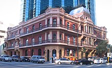
The Palace Hotel in Perth, Western Australia, is a landmark three-storey heritage listed building located in the city's central business district. Originally built in 1897 as a hotel during the gold rush period of Western Australia's history, it was converted to banking chambers and offices in the 1980s and now accommodates the Perth headquarters of Woods Bagot, Adapptor and Hatchd. The building is located on the most prominent intersection in the financial district of the city, at the corner of St Georges Terrace and William Street.
When the hotel opened for business on 18 March 1897 it was, although slightly smaller than some of its contemporary buildings in other capital cities in Australasia, described as "... one of the most beautiful and elegant hotels in Australasia". Other praise included: "... redolent of the bourgeois luxury and splendour of the Paris of Napoleon III" and later "... in its day, as sumptuous a hostelry as any in Melbourne or Sydney." It operated as licensed premises from 1897 until 1981. (Full article...) -
Severe Tropical Cyclone Glenda was among the strongest tropical cyclones to threaten Western Australia, though it weakened considerably before landfall and moved ashore in a lightly populated region. It began as a tropical low on 15 March in the Gulf of Carpentaria. The precursor disturbance drifted over Top End and later across the northeastern portion of Western Australia, and after emerging into the Indian Ocean it strengthened into a tropical storm. Aided by favourable environmental conditions, Glenda rapidly intensified to reach Category 5 status on the Australian cyclone scale, and with a peak intensity of 910 mbar it was among the strongest cyclones on record within the Australia region. On 30 March it moved ashore near Onslow as a Category 3 cyclone, and the next day it degenerated into a remnant tropical low over land.
The precursor disturbance produced heavy rainfall in the Kimberley region of Western Australia, causing record flooding and some road damage. Minor damage was reported at the final landfall of Glenda. Due to the sparse population and preparations made, the cyclone was not responsible for any deaths or injuries. However, its name was later retired from the list of tropical cyclone names. (Full article...) -
Bayswater is a suburb 6 kilometres (4 mi) north-east of the central business district (CBD) of Perth, the capital of Western Australia. It is just north of the Swan River, within the City of Bayswater local government area. It is predominantly a low-density residential suburb consisting of single-family detached homes. However, there are several clusters of commercial buildings, most notably in the suburb's town centre, around the intersection of Whatley Crescent and King William Street and a light industrial area in the suburb's east.
Prior to European settlement, the Mooro group of the Whadjuk Noongar people inhabited the area. In 1830, the year after the European settlement of the Swan River Colony, land along the river was divided between the colonists, who moved in soon after. Most either died or left in the months following, leaving the area undeveloped for most of the 19th century. In 1881, the Fremantle–Guildford railway line was built, triggering the founding of the Bayswater Estate, the first development in the area, and in 1897, the Bayswater Road Board was founded, giving Bayswater its own local government. At first, development consisted of nurseries, market gardens and dairies, but as time went on, Bayswater became more and more suburban. Today, Bayswater is fully suburbanised, with the subdividing of older lots being commonplace. Plans for apartments around Bayswater and Meltham railway stations are a contentious issue. (Full article...) -
Frederick Benjamin Carlin (27 July 1912 – 7 March 1981) was an Australian adventurer who was the first person to circumnavigate the world in an amphibious vehicle. Born in Northam, Western Australia, Carlin attended Guildford Grammar School in Perth, and later studied mining engineering at the Kalgoorlie School of Mines. After qualifying as an engineer, he worked on the Goldfields before emigrating to China in 1939 to work in a British coal mine. In World War II, Carlin was posted to the Indian Army Corps of Engineers, serving in India, Italy, and throughout the Middle East. After his discharge from service in 1946, he emigrated to the United States with his American wife, Elinore (née Arone).
Sparked by an idea he had whilst in the military, Carlin proposed that the couple honeymoon by crossing the Atlantic Ocean in a modified Ford GPA (an amphibious version of the Ford GPW Jeep), which they named the Half-Safe. Beginning their trip in Montreal, Quebec, Canada, the Carlins finally completed the transatlantic crossing in 1951 after unsuccessful attempts. From there, they travelled to Europe, temporarily settling in Birmingham to raise more money. They resumed their journey in 1954, travelling overland through the Middle East before arriving in Calcutta. After a short fundraising trip to Australia, Carlin's wife left to return to the United States. He resumed the journey with new partners, travelling through South-East Asia and the Far East to the northern tip of Japan, and then to Alaska. After an extended tour through the United States and Canada, he and Half-Safe returned to Montreal, having travelled over 17,000 kilometres (11,000 mi) by sea and 62,000 kilometres (39,000 mi) by land during the ten-year journey. Following Carlin's death in 1981, Half-Safe was acquired by Guildford Grammar, his old school, where it remains on display. (Full article...) -
Bayswater railway station is a suburban rail station in Bayswater, a suburb of Perth, Western Australia. It is the junction station for Transperth's Midland and Airport lines, and the Morley–Ellenbrook line when it opens in late 2024.
The station first opened in 1896 on the Perth to Midland railway with two side platforms and an adjacent goods yard. It served as the junction station for the Belmont spur line between 1896 and 1956. Bayswater station was rebuilt as an island platform just to the north in the late 1960s when the Midland line was converted from narrow gauge to dual gauge; the standard gauge trains were unable to fit between the side platforms. Around that time, the goods yard closed. (Full article...) -
Sherwood railway station (officially Sherwood Station and previously known as Kingsley Station) is a suburban railway station in Armadale, a suburb of Perth, Western Australia. It is on the Armadale line which is part of the Transperth network, and is 28.6 kilometres (17.8 mi) southwest of Perth station and 1.8 kilometres (1.1 mi) north of Armadale station. The station opened in 1973 as Kingsley, but was renamed to Sherwood in 1993. It consists of two side platforms with a pedestrian level crossing. It is not fully accessible due to steep ramps, wide gaps at the pedestrian level crossing, and wide gaps between the platform and train. Services are operated by Transperth Train Operations, a division of the state government's Public Transport Authority. Peak services reach seven trains per hour in each direction, whilst off-peak services are four trains per hour. (Full article...) -
Tropical Cyclone Alessia was the first tropical cyclone to affect the Northern Territory of Australia in November since Cyclone Joan in 1975. The storm was first identified as a tropical low on 20 November 2013 well to the northwest of Australia. Tracking generally west to west-southwest, the small system steadily organized into a tropical cyclone by 22 November. Maintaining a small central dense overcast, Alessia brushed the Kimberley region before making landfall in the Top End region with winds of 65 km/h (40 mph) on 23 and 24 November respectively. Some weakening took place as the system moved over land; however, reorganization occurred as it neared the Gulf of Carpentaria. After moving over water on 26 November, it redeveloped gale-force winds. Alessia reached its peak intensity on 27 November with winds of 85 km/h (53 mph) and a barometric pressure of 991 mbar (hPa; 29.26 inHg) and subsequently made its final landfall near Wollogorang. Weakening ensued once more as the storm traveled over land; though, Alessia's remnants looped eastward back over water before doubling back to the west. The system was last noted moving inland again over the Northern Territory on 1 December.
Throughout Alessia's existence, it caused only minimal damage. Several areas experienced gale-force winds, with gusts measured up to 109 km/h (68 mph) on Centre Island. Moderate to heavy rains accompanied the system as well, with a storm maxima of 290.4 mm (11.43 in) also occurring on Centre Island. (Full article...) -
108 St Georges Terrace or Palace Tower (formerly known as the South32 Tower, the Bankwest Tower, the Bond Tower and the R&I Tower) is a 50-storey office tower in Perth, Western Australia. Completed in 1988, the building measures 214 metres (702 ft) to its roof and 247 metres (810 ft) to the tip of its communications antenna. It was the tallest building in Perth from its completion in 1988 until 1992 when it was overtaken in height by Central Park. As of 2023, it is the third-tallest building in the city. The concrete tower has a distinctive profile, with a triangular plan.
The site occupied by the tower was home to the Palace Hotel, and organised opposition was formed to try to save that building from demolition to make way for an office tower. The site was subsequently acquired by businessman Alan Bond and the tower was approved and constructed in a plan that would retain much of the Palace Hotel. The tower then remained the headquarters of Bond's companies until their collapse. The tower has also been the headquarters of Bankwest (formerly known as the R&I Bank), between its completion and 2012. In 2015, it became the headquarters of mining company South32. (Full article...)


.jpg)


.jpg)
Did you know (auto-generated)

- ... that Nick Goiran, a member of the Western Australian Legislative Council, proposed 357 amendments to a voluntary assisted dying bill?
- ... that politician John D'Orazio helped to secure a three-year trial of daylight saving time in Western Australia?
- ... that Western Australia was the second Australian state to legalise voluntary assisted dying?
- ... that the search for a lost radioactive capsule along a 1,400-kilometre (870 mi) stretch of road in Western Australia was likened to looking for a needle in a haystack?
- ... that Mertome Village in Bayswater, Western Australia was the first aged care complex to be built by a local government in Australia?
- ... that Bill Dunn, an Indigenous Australian pastoralist approaching retirement, sold his station at half-price to the Jigalong community despite receiving full-price offers from non-Indigenous people?
Categories

More portals
More did you know...

- ...that when the 1987 America's Cup was raced off Fremantle, Western Australia it was the first time for 132 years that the regatta had not been hosted by the New York Yacht Club?
- ...that the original Victoria Dam, constructed in 1891, was the first dam in Western Australia, and it stood for almost 100 years before being replaced with the current dam?
- ...that Anglican bishop Kay Goldsworthy was consecrated as the first woman bishop of any Australian church on 22 May 2008?
Related WikiProjects

Things you can do
Here are some tasks you can do to help with WikiProject Western Australia:
Associated Wikimedia
The following Wikimedia Foundation sister projects provide more on this subject:
-
 Commons
Free media repository -
 Wikibooks
Free textbooks and manuals -
 Wikidata
Free knowledge base -
 Wikinews
Free-content news -
 Wikiquote
Collection of quotations -
 Wikisource
Free-content library -
 Wikispecies
Directory of species -
 Wikiversity
Free learning tools -
 Wikivoyage
Free travel guide -
 Wiktionary
Dictionary and thesaurus


© MMXXIII Rich X Search. We shall prevail. All rights reserved. Rich X Search