Back Portal:Australia Occidental Spanish Portail:Australie-Occidentale French Portal:Austrália Ocidental Portuguese
Introduction
 Western Australia (WA) is a state of Australia occupying the western third of the land area of the Australian continent.[text–source integrity?] It is bounded by the Indian Ocean to the north and west, the Southern Ocean to the south, the Northern Territory to the north-east, and South Australia to the south-east. With a total land area of 2,527,013 square kilometres (975,685 sq mi), Western Australia is Australia's largest state as well as the second-largest subdivision of any country on Earth, surpassed only by the Sakha Republic in eastern Russia. Western Australia has a diverse range of climates, including tropical conditions in the Kimberley, deserts in the interior (including the Great Sandy Desert, Little Sandy Desert, Gibson Desert, and Great Victoria Desert) and a Mediterranean climate on the south-west and southern coastal areas. the state has 2.91 million inhabitants—11 percent of the national total. Over 90 percent of the state's population live in the south-west corner and around 80 percent live in the state capital Perth, leaving the remainder of the state sparsely populated. The Trans-Australian Railway and the Eyre Highway traverse the Nullarbor Plain in the state's south-east, providing the principal connection between Western Australia and the population centres in the eastern states. (Full article...)
|


-8a.jpg)

.JPG)


.jpg)


(Northern
Territory) |
 Good articles -
-

Bayswater railway station is a suburban rail station in Bayswater, a suburb of Perth, Western Australia. It is the junction station for Transperth's Midland and Airport lines, and the Morley–Ellenbrook line when it opens in late 2024.
The station first opened in 1896 on the Perth to Midland railway with two side platforms and an adjacent goods yard. It served as the junction station for the Belmont spur line between 1896 and 1956. Bayswater station was rebuilt as an island platform just to the north in the late 1960s when the Midland line was converted from narrow gauge to dual gauge; the standard gauge trains were unable to fit between the side platforms. Around that time, the goods yard closed. (Full article...) -
The Narrows Bridge is a freeway and railway crossing of the Swan River in Perth, Western Australia.
Made up of two road bridges and a railway bridge constructed at a part of the river known as the Narrows, located between Mill Point and Point Lewis, it connects the Mitchell and Kwinana Freeways, linking the city's northern and southern suburbs. The original road bridge was opened in 1959 and was the largest precast prestressed concrete bridge in the world. Construction of the northern interchange for this bridge necessitated the reclamation of a large amount of land from the river. (Full article...) -
The West Coast Eagles are an Australian rules football team based in Perth, Western Australia. The 2021 AFL Women's season was their second season in that competition, their first season with Daniel Pratt as coach, and their second season with Emma Swanson as captain. They won two out of the nine games they played, their only wins being by one point against Gold Coast and 39 points against Geelong. They finished 12th out of 14 on the ladder, missing out on qualifying for finals.
The season was marked by many injuries to the team's players, most notably to star player Dana Hooker, who was unable to play for most of the season due to a kitchen accident. Young midfielders Mikayla Bowen and Isabella Lewis were standout players, both receiving Rising Star nominations. Lewis was the team's best and fairest player, winning the West Coast Club Champion medal. Bowen was the team's sole inclusion in the All-Australian squad. Grace Kelly was the team's leading goalkicker, with seven goals. (Full article...) -
The Thornlie line is a temporarily closed suburban railway line and service in Perth, Western Australia, operated by the Public Transport Authority as part of the Transperth system. The Thornlie line is a branch of the Armadale line which opened on 7 August 2005 and runs for 2.9 kilometres (1.8 mi) parallel to the Kwinana freight railway between the Armadale line at Kenwick and Thornlie station. Thornlie line services continued north of Kenwick along the Armadale line to Perth station, stopping at most stations, in contrast to Armadale line services, which skipped most stations along that section. The Thornlie line has been suspended since 20 November 2023 due to construction work; it is planned to reopen in mid-2025.
The Thornlie line originated from initial plans for the Mandurah line, which was to branch off the Armadale line and run along the Kwinana freight railway. The Mandurah line's planned route changed in 2001, but not before tunnels were built for the line to exit the Armadale line at Kenwick and enter the Kwinana Freeway. It was decided to build the Thornlie line instead as a one-station branch of the Armadale line. The main construction contract was awarded to Barclay Mowlem in 2004 and the Thornlie line opened on 7 August 2005. (Full article...) -
Oats Street railway station is a temporarily-closed Transperth suburban railway station in Western Australia, located in the Perth suburbs of Carlisle and East Victoria Park. The station was served by the Armadale and Thornlie lines prior to its closure in November 2023.
Oats Street station opened on 28 November 1954, as the introduction of diesel railcars made it possible to build stations closer together. The station consisted of two side platforms north of the Oats Street level crossing. The CircleRoute bus began operating in 1998, allowing access to Curtin University from the Armadale line. A bus interchange was constructed soon thereafter, and Oats Street soon became one of the most important stations on the Armadale line. The Thornlie line opened in 2005, with Oats Street station being one of the few transfer stations between the two lines, further increasing its importance. Since 20 November 2023, the station has been closed to allow for the railway to be elevated and for Oats Street station to be rebuilt as an elevated station, as part of the Victoria Park-Canning Level Crossing Removal Project. The new station will straddle Oats Street and feature an expanded bus interchange. It is planned to reopen in mid-2025. (Full article...) -
North West Coastal Highway is a generally north-south Western Australian highway which links the coastal city of Geraldton with the town of Port Hedland. The 1,300-kilometre-long (808 mi) road, constructed as a sealed two-lane single carriageway, travels through remote and largely arid landscapes. Carnarvon is the only large settlement on the highway, and is an oasis within the harsh surrounding environment. The entire highway is allocated National Route 1, part of Australia's Highway 1, and parts of the highway are included in tourist routes Batavia Coast Tourist Way and Cossack Tourist Way. Economically, North West Coastal Highway is an important link to the Mid West, Gascoyne and Pilbara regions, supporting the agricultural, pastoral, fishing, and tourism industries, as well as mining and offshore oil and gas production.
In Geraldton, the highway begins at a grade separated interchange with Brand Highway and roads providing access to the port and town centre. Two major roads link the North West Coastal Highway to the inland Great Northern Highway: Geraldton–Mount Magnet Road in Geraldton, and Nanutarra Munjina Road at Nanutarra, 845 kilometres (525 mi) further north. Several roads link provide access to coastal towns and attractions, including Shark Bay Road, Onslow Road and Karratha Road. With few towns on the highway, roadhouses are the only settlements for long stretches. North West Coastal Highway ends at Great Northern Highway, 30 kilometres (19 mi) out from Port Hedland. (Full article...) -
On 26 June 1950, a Douglas DC-4 Skymaster aircraft departed from Perth, Western Australia, for an eight-hour flight to Adelaide, South Australia. It crashed 22 minutes after take-off, 35 miles (56 km) east of Perth Airport. All 29 occupants were killed in the accident; one initially survived, but died six days later. It was the worst civil aviation accident in Australia.
As the aircraft flew eastwards over the outer suburbs of Perth numerous witnesses observed that it was flying at a lower altitude than usual for the daily Skymaster services, and at least one of the engines was running roughly and backfiring at regular intervals. In the minutes before it crashed, witnesses heard a number of different engine noises – sometimes operating normally, sometimes all engine noise ceased, only to be replaced by what was described as a very loud, high-pitched "scream". When the wrecked engines were examined many weeks after the accident a significant amount of corrosion product was found in the fuel system within two of the engines. After a preliminary investigation, Investigators from the Department of Civil Aviation believed the water responsible for the corrosion was also responsible for rough running of at least one engine, and ultimately temporary loss of power from all engines on at least one occasion. The investigators did not find a likely source for the water. (Full article...) -
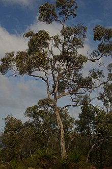
Eucalyptus wandoo, commonly known as wandoo, dooto, warrnt or wornt and sometimes as white gum, is a small to medium-sized tree that is endemic to the southwest of Western Australia. It has smooth bark, lance-shaped adult leaves, flower buds in groups of nine to seventeen, white flowers and conical to cylindrical fruit. It is one of a number of similar Eucalyptus species known as wandoo.
E. wandoo was first described in 1934 by the Australian botanist William Faris Blakely in his book A Key to the Eucalypts using material collected by the English collector Augustus Frederick Oldfield from a sand plain along the Kalgan River. , Plants of the World Online lists Eucalyptus redunca var. elata as a taxonomic synonym of E. wandoo. (Full article...) -
Lakelands railway station is a railway station along the Mandurah line on the Transperth network in Western Australia. The station is in the Mandurah suburb of Lakelands, 6.5 kilometres (4.0 mi) north of Mandurah station and 64.5 kilometres (40.1 mi) south of Perth Underground station. Construction started in 2021 and it opened on 11 June 2023.
Provisions for the station were made when the Mandurah line was originally built during the 2000s. There were several proposals to build the station during the 2010s, but when the state Labor Party came to power in 2017, it had committed to build the nearby Karnup station but not Lakelands station. Meanwhile, the federal Liberal Party wanted to build Lakelands station, so it committed to funding 80% of the A$80 million required to build the station. The federal government refused requests for the funding to be transferred to the Karnup station project, therefore that project was put on hold so that the state could fund Lakelands station. This resulted in accusations that the federal government was pork barrelling as Lakelands station was in Liberal MP Andrew Hastie's seat whereas Karnup station was in a safe Labor seat held by Madeleine King. (Full article...) -
John Trezise Tonkin AC (2 February 1902 – 20 October 1995) was an Australian politician who was the premier of Western Australia from 3 March 1971 to 8 April 1974. A member of the Labor Party, Tonkin was previously a minister in the John Willcock, Frank Wise and Bert Hawke governments, and a member of the Western Australian Legislative Assembly from April 1933 to February 1977, making him the longest-serving member of the Parliament of Western Australia as of 2021.
Tonkin was born in the Goldfields town of Boulder, Western Australia, the eldest of three children. His family moved several times before returning to Boulder, where he attended Boulder City Central School and Eastern Goldfields High School. After several successive jobs, he graduated from Claremont Teachers College and became a teacher, mainly working in small schools in rural areas. After several unsuccessful attempts to enter state parliament, Tonkin was elected as the member for North-East Fremantle in the 1933 state election. (Full article...) -
Frederick Benjamin Carlin (27 July 1912 – 7 March 1981) was an Australian adventurer who was the first person to circumnavigate the world in an amphibious vehicle. Born in Northam, Western Australia, Carlin attended Guildford Grammar School in Perth, and later studied mining engineering at the Kalgoorlie School of Mines. After qualifying as an engineer, he worked on the Goldfields before emigrating to China in 1939 to work in a British coal mine. In World War II, Carlin was posted to the Indian Army Corps of Engineers, serving in India, Italy, and throughout the Middle East. After his discharge from service in 1946, he emigrated to the United States with his American wife, Elinore (née Arone).
Sparked by an idea he had whilst in the military, Carlin proposed that the couple honeymoon by crossing the Atlantic Ocean in a modified Ford GPA (an amphibious version of the Ford GPW Jeep), which they named the Half-Safe. Beginning their trip in Montreal, Quebec, Canada, the Carlins finally completed the transatlantic crossing in 1951 after unsuccessful attempts. From there, they travelled to Europe, temporarily settling in Birmingham to raise more money. They resumed their journey in 1954, travelling overland through the Middle East before arriving in Calcutta. After a short fundraising trip to Australia, Carlin's wife left to return to the United States. He resumed the journey with new partners, travelling through South-East Asia and the Far East to the northern tip of Japan, and then to Alaska. After an extended tour through the United States and Canada, he and Half-Safe returned to Montreal, having travelled over 17,000 kilometres (11,000 mi) by sea and 62,000 kilometres (39,000 mi) by land during the ten-year journey. Following Carlin's death in 1981, Half-Safe was acquired by Guildford Grammar, his old school, where it remains on display. (Full article...) -
Severe Tropical Cyclone Bobby set numerous monthly rainfall records in parts of the Goldfields-Esperance regions of Western Australia, dropping up to 400 mm (16 in) of rain in February 1995. The fourth named storm of the 1994–95 Australian region cyclone season, Bobby developed as a tropical low embedded within a monsoon trough situated north of the Northern Territory coastline on 19 February. The storm gradually drifted southwestward and later southward under low wind shear, strengthening enough to be assigned the name Bobby by the Australian Bureau of Meteorology (BoM). The storm rapidly deepened as it approached the coast of Western Australia, and attained its peak intensity of 925 mbar (hPa; 27.32 inHg) at 0900 UTC on 24 February with 10-minute maximum sustained winds of 195 km/h (120 mph). After making landfall as a somewhat weaker cyclone near Onslow, the remnants of Bobby drifted southeastward, gradually weakening, before dissipating over the southern reaches of Western Australia.
Bobby inflicted minor damage throughout Western Australia, dropping copious rainfall and forcing the closure of many facilities and roads. The storm's destruction was most severe in Onslow, where 20 residences suffered damage. Elsewhere, Bobby knocked out power and water supplies, unroofed houses, tore off rain gutters, toppled fences, and smashed windows. The flooding of a 17 km (11 mi) stretch of the Eyre Highway stranded approximately 1000 vehicles, although the backup was later cleared more than a week later. Flooding disrupted mining and drilling operations throughout southwestern Australia, costing the industry upwards of $50 million (1995 AUD; $38.7 million USD). Numerous Australian Army and State Emergency Service (SES) personnel were involved in cleanup and recovery efforts after the cyclone's passage, while power and water service was restored to those cut off during the storm. Overall, the cyclone caused eight deaths and $11 million (1995 AUD; $8.5 million USD) in damage along its course across Western Australia. (Full article...) -
Great Northern Highway is an Australian highway that links Western Australia's capital city Perth with its northernmost port, Wyndham. With a length of almost 3,200 kilometres (2,000 mi), it is the longest highway in Australia, with the majority included as part of the Perth Darwin National Highway. The highway, which travels through remote areas of the state, is constructed as a sealed, predominantly two-lane single carriageway, but with some single-lane bridges in the Kimberley. Economically, it provides vital access through the Wheatbelt and Mid West to the resource-rich regions of the Pilbara and Kimberley. In these areas, the key industries of mining, agriculture and pastoral stations, and tourism are all dependent on the highway.
In Perth, the highway begins in Midland near Great Eastern Highway, and further north intersects the Reid and Roe highways, which together form Perth's ring road. There are also three rural highways that spur off Great Northern Highway. Brand Highway and North West Coastal Highway provide an alternative coastal route between Muchea and Port Hedland, while Victoria Highway carries the National Highway route and interstate traffic into the Northern Territory. Various road routes are allocated to sections of Great Northern Highway, including the Highway 1 routes National Route 1 and National Highway 1, as well as National Highway 95. (Full article...) -
Aubin Grove railway station is a suburban railway station serving Atwell, Aubin Grove, Hammond Park and Success, which are suburbs of Perth, Western Australia. It is on the Mandurah line, which is part of the Transperth network, and is located immediately north of Russell Road in the median of the Kwinana Freeway. It has two platform faces on a singular island platform, which is linked to either side of the freeway by a pedestrian overpass. Services run every 10 minutes during peak and every 15 minutes between peak. The journey to Perth station is 23.8 kilometres (14.8 mi) and takes 21 minutes. The station has a bus interchange with four bus stands and seven regular bus routes.
Construction of the station was promised by both major political parties ahead of the 2013 Western Australian state election. A tender was released for the station's construction in July 2014, with a projected cost of A$80 million for the whole project, including the purchase of two Transperth B-series trains. The design contract was awarded in February 2015 to a joint venture between Coniglio Ainsworth Architects and M. P. S. Architects. The scope of the project was broadened in April 2015 to include the widening of the Russell Road bridge over the freeway, which increased the project budget to $105 million. Construction on the station began in March 2016, and it was opened on 23 April 2017, with the final cost being $125 million. (Full article...) -
Tropical Cyclone Alessia was the first tropical cyclone to affect the Northern Territory of Australia in November since Cyclone Joan in 1975. The storm was first identified as a tropical low on 20 November 2013 well to the northwest of Australia. Tracking generally west to west-southwest, the small system steadily organized into a tropical cyclone by 22 November. Maintaining a small central dense overcast, Alessia brushed the Kimberley region before making landfall in the Top End region with winds of 65 km/h (40 mph) on 23 and 24 November respectively. Some weakening took place as the system moved over land; however, reorganization occurred as it neared the Gulf of Carpentaria. After moving over water on 26 November, it redeveloped gale-force winds. Alessia reached its peak intensity on 27 November with winds of 85 km/h (53 mph) and a barometric pressure of 991 mbar (hPa; 29.26 inHg) and subsequently made its final landfall near Wollogorang. Weakening ensued once more as the storm traveled over land; though, Alessia's remnants looped eastward back over water before doubling back to the west. The system was last noted moving inland again over the Northern Territory on 1 December.
Throughout Alessia's existence, it caused only minimal damage. Several areas experienced gale-force winds, with gusts measured up to 109 km/h (68 mph) on Centre Island. Moderate to heavy rains accompanied the system as well, with a storm maxima of 290.4 mm (11.43 in) also occurring on Centre Island. (Full article...)


Did you know (auto-generated)

- ... that Bill Dunn, an Indigenous Australian pastoralist approaching retirement, sold his station at half-price to the Jigalong community despite receiving full-price offers from non-Indigenous people?
- ... that the search for a lost radioactive capsule along a 1,400-kilometre (870 mi) stretch of road in Western Australia was likened to looking for a needle in a haystack?
- ... that Nick Goiran, a member of the Western Australian Legislative Council, proposed 357 amendments to a voluntary assisted dying bill?
- ... that politician John D'Orazio helped to secure a three-year trial of daylight saving time in Western Australia?
Categories

More portals
More did you know...

- ...that when the 1987 America's Cup was raced off Fremantle, Western Australia it was the first time for 132 years that the regatta had not been hosted by the New York Yacht Club?
- ...that the original Victoria Dam, constructed in 1891, was the first dam in Western Australia, and it stood for almost 100 years before being replaced with the current dam?
- ...that Anglican bishop Kay Goldsworthy was consecrated as the first woman bishop of any Australian church on 22 May 2008?
Related WikiProjects

Things you can do
Here are some tasks you can do to help with WikiProject Western Australia:
Associated Wikimedia
The following Wikimedia Foundation sister projects provide more on this subject:
-
 Commons
Free media repository -
 Wikibooks
Free textbooks and manuals -
 Wikidata
Free knowledge base -
 Wikinews
Free-content news -
 Wikiquote
Collection of quotations -
 Wikisource
Free-content library -
 Wikispecies
Directory of species -
 Wikiversity
Free learning tools -
 Wikivoyage
Free travel guide -
 Wiktionary
Dictionary and thesaurus


© MMXXIII Rich X Search. We shall prevail. All rights reserved. Rich X Search