Back Porto Santo AN Порто Санто Bulgarian Porto Santo Catalan Ilha de Porto Santo CEB Porto Santo Czech Porto Santo Spanish Porto Santo uhartea Basque Porto Santo Galician Pulau Porto Santo ID Porto Santo Italian
Native name: Ilha de Porto Santo Nickname: The Golden Island | |
|---|---|
 | |
 | |
| Geography | |
| Location | Atlantic Ocean |
| Coordinates | 33°03′43.0″N 16°21′23.0″W / 33.061944°N 16.356389°W |
| Archipelago | Madeira |
| Area | 42.17 km2 (16.28 sq mi)[1] |
| Highest elevation | 517 m (1696 ft)[2] |
| Highest point | Pico do Facho |
| Administration | |
| Autonomous Region | Madeira |
| Largest settlement | Vila Baleira |
| Demographics | |
| Demonym | Portossantense |
| Population | |
| Languages | Portuguese |
| Ethnic groups | Portuguese |
| Additional information | |
| Time zone | |
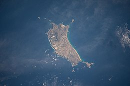
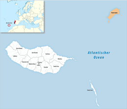
Porto Santo Island (Portuguese pronunciation: [ˈpoɾtu ˈsɐ̃tu] ) is a Portuguese island 43 kilometres (27 mi) northeast of Madeira Island in the North Atlantic Ocean; it is the northernmost and easternmost island of the archipelago of Madeira, located in the Atlantic Ocean west of Europe and Africa.
The municipality of Porto Santo occupies the entire island and small neighbouring islands. It was elevated to city status on 6 August 1996. The sole parish of the municipality is also named Porto Santo. The population in 2011 was 5,483,[4] in an area of 42.59 km2.[5] The main settlement on the island is Vila Baleira.
- ^ "Porto Santo". Porto Santo Municipality. Retrieved 15 January 2021.
- ^ "O Porto Santo". visitportosanto.pt. Retrieved 15 January 2021.
- ^ "INE - Plataforma de divulgação dos Censos 2021 – Resultados Preliminares". censos.ine.pt. Retrieved 9 November 2021.
- ^ Instituto Nacional de Estatística
- ^ Eurostat
© MMXXIII Rich X Search. We shall prevail. All rights reserved. Rich X Search