Back Portsmouth International Airport at Pease CEB Portsmouth International Airport at Pease German فرودگاه بینالمللی پورتسموث ات پیس Persian Port lotniczy Portsmouth Polish Aeroportul Portsmouth at Pease Romanian Фурудгоҳи биналмилалӣ пуртсмус от пис Tajik پورٹسماؤت بین الاقوامی ہوائی اڈا ایٹ پیز Urdu
Portsmouth International Airport at Pease | |||||||||||
|---|---|---|---|---|---|---|---|---|---|---|---|
 | |||||||||||
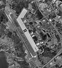
 USGS 1998 orthophoto | |||||||||||
| Summary | |||||||||||
| Airport type | Public / military | ||||||||||
| Owner | Pease Development Authority | ||||||||||
| Serves | Portsmouth, New Hampshire | ||||||||||
| Location | Portsmouth / Newington, New Hampshire, USA | ||||||||||
| Elevation AMSL | 100 ft / 30 m | ||||||||||
| Coordinates | 43°04′41″N 070°49′24″W / 43.07806°N 70.82333°W | ||||||||||
| Website | FlyPSMairport.com | ||||||||||
| Maps | |||||||||||
 FAA airport diagram | |||||||||||
 | |||||||||||
| Runways | |||||||||||
| |||||||||||
| Statistics (2019) | |||||||||||
| |||||||||||
Portsmouth International Airport at Pease[1][2] (IATA: PSM, ICAO: KPSM, FAA LID: PSM), formerly known as Pease International Airport, is a joint civil and military use airport located one nautical mile (2 km) west of the central business district of Portsmouth, a city in Rockingham County, New Hampshire, United States. It is owned by the Pease Development Authority.[2] It is included in the Federal Aviation Administration (FAA) National Plan of Integrated Airport Systems for 2017–2021, in which it is categorized as a non-hub primary commercial service facility.[4]
The airport is located within the Pease International Tradeport,[5] a result of the ongoing redevelopment of the former Pease Air Force Base which was closed under Base Realignment and Closure (BRAC) Commission action in the late 1980s and early 1990s.
- ^ a b Portsmouth International Airport at Pease, official site
- ^ a b c FAA Airport Form 5010 for PSM PDF. Federal Aviation Administration. Effective June 5, 2008.
- ^ Cite error: The named reference
gcr1was invoked but never defined (see the help page). - ^ "List of NPIAS Airports" (PDF). FAA.gov. Federal Aviation Administration. October 21, 2016. Retrieved November 27, 2016.
- ^ Pease International Tradeport, official site
© MMXXIII Rich X Search. We shall prevail. All rights reserved. Rich X Search