Prague 19
Praha 19 | |
|---|---|
Municipal District of Prague Administrative District of Prague | |
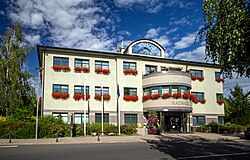
 Prague 19 town hall | |
 Location of Prague 19 in Prague | |
| Coordinates: 50°8′0″N 14°32′58″E / 50.13333°N 14.54944°E | |
| Country | Czech Republic |
| Region | Prague |
| Government | |
| • Mayor | Pavel Žďárský |
| Area | |
| • Total | 5.99 km2 (2.31 sq mi) |
| Population (2021) | |
| • Total | 7,216 |
| • Density | 1,200/km2 (3,100/sq mi) |
| Time zone | UTC+1 (CET) |
| • Summer (DST) | UTC+2 (CEST) |
| Postal code | 197 00 |
| Website | http://www.praha19.cz |
Prague 19, also known as Kbely (German: Gbel), is a municipal district (městská část) in Prague. It is located in the north-eastern part of the city. It is formed by one cadastre, Kbely. As of 2008[update], there were 6,149 inhabitants living in Prague 19.
The administrative district (správní obvod) of the same name consists of municipal districts Prague 19, Satalice and Vinoř.

© MMXXIII Rich X Search. We shall prevail. All rights reserved. Rich X Search


