Promontory of Quebec
French: Colline de Québec | |
|---|---|
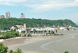
 View from Anse-au-Foulon, with Cap Diamant to the east | |
 Topographic map of the Promontory of Quebec | |
| Coordinates: 46°46′19″N 71°18′07″W / 46.7720°N 71.3020°W | |
| Location | Quebec City, Quebec, Canada |
| Orogeny | Appalachian |
| Geology | Schist |
| Dimensions | |
| • Length | 13 km (8.1 mi) |
| • Width | 1–4 km (0.62–2.49 mi) |
| Highest elevation | 110 m (360 ft) (Sainte-Foy Summit) |
| Topo map | NTS 21L14 Québec |
In Quebec City, the term promontory of Quebec refers to the area on which is built the upper part of the borough of La Cité-Limoilou, including Old Quebec (where the promontory is referred to as Cap Diamant). This area covers the eastern half of a larger plateau attested in French as colline or even plate-forme de Québec (Quebec hill).[1] The western portion of this plateau is occupied by upper Sainte-Foy–Sillery–Cap-Rouge (ie. most of this borough — whereas for La Cité-Limoilou, less than half of it is located uptown).
- ^ Serge Courville; Robert Garon (2001). Québec: ville et capitale (in French). Presses Université Laval. pp. 22–23. ISBN 978-2-7637-7674-3.
© MMXXIII Rich X Search. We shall prevail. All rights reserved. Rich X Search
