Back مقاطعة بتنام (أوهايو) Arabic Putnam County, Ohio BAR Путнам (окръг, Охайо) Bulgarian পুতনাম কাউন্টি, ওহাইও BPY Putnam Gông (Ohio) CDO Putnam County (kondado sa Tinipong Bansa, Ohio) CEB Putnam County (Ohio) Czech Putnam County, Ohio Welsh Putnam County (Ohio) Danish Putnam County (Ohio) German
Putnam County | |
|---|---|
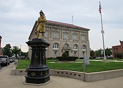
 Putnam County Courthouse | |
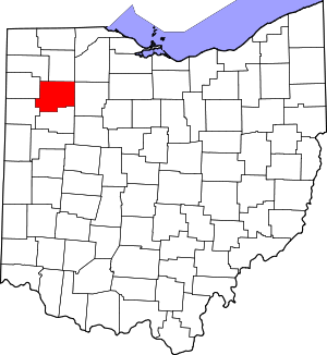
 Location within the U.S. state of Ohio | |
 Ohio's location within the U.S. | |
| Coordinates: 41°01′N 84°08′W / 41.02°N 84.13°W | |
| Country | |
| State | |
| Founded | January 3, 1834 |
| Named for | Israel Putnam |
| Seat | Ottawa |
| Largest village | Ottawa |
| Area | |
| • Total | 484 sq mi (1,250 km2) |
| • Land | 483 sq mi (1,250 km2) |
| • Water | 1.8 sq mi (5 km2) 0.4% |
| Population (2020) | |
| • Total | 34,451 |
| • Density | 71/sq mi (27/km2) |
| Time zone | UTC−5 (Eastern) |
| • Summer (DST) | UTC−4 (EDT) |
| Congressional district | 5th |
| Website | www |
Putnam County is a county located in the northwestern part of the U.S. state of Ohio. As of the 2020 census, the population was 34,451.[1] Its county seat is Ottawa.[2] The county was created in 1820 and later organized in 1834.[3] Its name is in honor of Israel Putnam, a colonial officer in the French and Indian War, who served as a general in the American Revolutionary War.[4] The Blanchard River, which passes through the county, was a key transportation route for early European-American settlers.
- ^ 2020 census
- ^ "Find a County". National Association of Counties. Retrieved June 7, 2011.
- ^ "Ohio: Individual County Chronologies". Ohio Atlas of Historical County Boundaries. The Newberry Library. 2007. Archived from the original on April 6, 2016. Retrieved February 14, 2015.
- ^ Warren, Robert (May 31, 1953). "Blanchard River Brought Pioneers To Putnam". Toledo Blade. p. 3. Retrieved April 30, 2015.
© MMXXIII Rich X Search. We shall prevail. All rights reserved. Rich X Search

